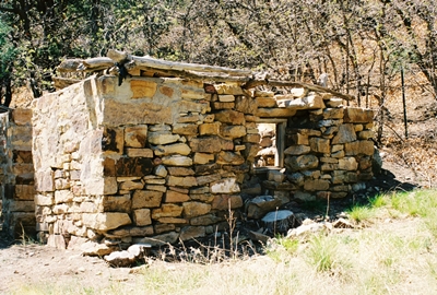
A crumbling stone cabin is now all that welcomes you to Tollgate Canyon.
If you’re reading this it means I've managed to successfully upload the first post of new content on City of Dust since January 2018. Wow. It feels like that was a million years ago. Professionally, personally, geographically…globally. Everything is different. Some of that explains my long absence from this blog. However, I hope this marks the return of the long-form (or longish-form, in this case) pieces that I eventually compiled in “Abandoned New Mexico: Ghost Towns, Endangered Architecture, and Hidden History,” the publication of which also pulled me away from the blog. But I ain’t complaining! It’s good to be at least attempting a comeback, and we shall see how things go!
I’ve written a number of times about the Belen Cutoff, the rail line built across east-central New Mexico by the Atchison, Topeka and Santa Fe Railway as a way to avoid the steep grade over Raton Pass. Completed in 1906, the Belen Cutoff provided a much flatter way to get trains through the state and is still being used today. It’s the main reason villages like YESO, TAIBAN, NEGRA, RICARDO, and many others came to exist. Or at least persisted, if only until the trains came to need diesel instead of water in the 1950s.
But the railroad wasn’t the first entity that was often unhappy to be going over Raton Pass, with its difficult ascent and dangerously unpredictable weather. In the 1800s, those traveling the Santa Fe Trail between New Mexico Territory and eastern Colorado by horse, mule, wagon, or foot frequently wished for something less arduous, as well; the Mountain Route of the famed trail went right over the Pass. And so it came to be that Tollgate Canyon was established which, unlike the Belen Cutoff, is now largely forgotten and rarely used by anybody other than local travelers.
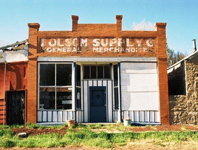
The Folsom Supply Co. building in Folsom, New Mexico.
Somewhere around 1870, Bazil “Baz” Metcalf, after traveling the Santa Fe Trail in an ox-drawn wagon from Missouri several years prior, was hired to work on the Cross L Ranch, then recently established by the Hall Brothers on the Dry Cimarron River. Baz got to thinking that creating a route for wagon freight and travelers along the nearby Santa Fe Trail that avoided Raton Pass would be helpful and possibly quite lucrative. In fact, a short canyon that headed south out of Emory Gap, New Mexico, and into the Dry Cimarron Valley provided a perfect place to build a toll road. Even the military could use this road to move between Fort Union in New Mexico Territory through the new settlement of Granada, Colorado, and into Bent’s Fort.
The road was completed in 1873, and Metcalf installed everything he thought might be useful, which included a store, a saloon, and a chain across the road that stretched between two boulders. If you were traveling by buggy, Metcalf charged 35 cents. A two-horse team ran 40 cents, while a four-horse wagon cost 75. There was a fee for cattle, too, which were sent north to feed the military posts and mining camps. Metcalf’s brother, John, minded the tollgate and watched Baz’s ranch when Baz was trading in the territory.
Native American raids were always a possibility, and in 1874, a year after Baz opened the road, Comanche and Kiowa attackers killed 17 settlers in the Dry Cimarron Valley. The Metcalf brothers survived that incident, and Baz escaped injury during another brush in 1876.
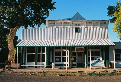
Built in 1896, the Doherty Mercantile now operates as the Folsom Museum, within which treasures await.
For 12 years, from 1873 to 1885, Tollgate Canyon operated as an important conduit for goods and people, largely creating the Fort Union-Granada Road. But in 1885, Metcalf decided to move to the Texas panhandle, where he would fence-in over 30 miles demarcating the northern boundary of the XIT Ranch. He used 5,200+ cedar posts to do it. At over 3,000,000 acres, the XIT would then become the largest fenced ranch in the world. Baz sold his toll road to Mike Devoy, but the clock was ticking on its usefulness, and with the arrival of the Colorado and Southern Railroad in 1888, Tollgate Canyon’s prominence disappeared in the blink of an eye.
The road that led through Tollgate Canyon is now NM Highway 551, just northeast of Folsom, in northwestern Union County, and the place where Baz collected his tolls is about two miles northwest of the intersection with NM Highway 456. All that indicates the location is a state historical marker and the crumbling stone cabin shown at the top of this post.
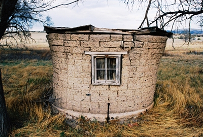
An old chicken coop in Capulin, New Mexico, near Folsom and not far from Tollgate Canyon.
However, you can see the ragged trunk that once held the tolls at the Folsom Museum. In fact, the best online history of Tollgate Canyon--and the one from which I got most of this information--was posted by the Folsom Museum RIGHT HERE. Check it out for more photos, too. You can also see Tollgate Canyon during the museum’s yearly Dry Cimarron River History Tour, which occurs in May and is how I came to visit it myself. For more info on all that, I highly recommend becoming a regular visitor to the Folsom Museum’s WEBSITE.
And there’s the first post in nearly five years! I’ve already got the next one drafted, but I’ll keep quiet as to more specifics so as not to jinx myself. Thanks to everyone that’s supported my endeavors, and I hope ya’ll have been hanging in there as best you can!
