During the years of the Civil War, with most able-bodied men sent off to the fray, traversing the Santa Fe Trail became even more treacherous than usual. Without the armed accompaniment that travelers had come to rely on, Native American tribes found it easier to attack settlers and traders moving along the trail, including those on the Cimarron Cut-off, or Dry Route, as it was also called. This alternate route sliced through what is now the western edge of the Oklahoma Panhandle as it entered New Mexico Territory, and while worryingly dry it often was, it was attractive since it cut 100 miles and 10 days off the Mountain Route. At most times it was also considered safer, avoiding the difficult Raton Pass and its steep 7,835' of elevation. But as attacks persisted along the Cimarron Cut-off throughout 1861 and 1862, the military tried to gain control. Among those in the field was Lieutenant Colonel Christopher Carson, also known as Kit, who was sent out to suppress raids by the Comanche and Kiowa, in particular.
Following a reasonably quiet winter of 1863, that spring found the Apache, Arapaho, Cheyenne, Comanche, and Pawnee assembled along the Arkansas River in numbers so large that the trail was actually closed to travel. The following year, in the spring of 1864, both the Cimarron Cut-off and the Mountain Route were back under steady attack. The military had completely lost control by June, and settlers and wagon trains alike were under fierce assault as the tribes tried in earnest to drive them from the land. In the Dry Cimarron Valley, along what is now the Oklahoma-New Mexico border, stone forts were built on mesas with settlers running to them, rifles in hand, whenever a Native American was seen.
Wagon ruts are still visible on the Cimarron Cut-off.
Raids continued into the summer of 1864, and in the second week of August, Comanche killed five men at Lower Cimarron Springs. On the 19th of that month, near one of the Cimarron springs, an entire caravan was wiped out, with ten men lost and 130 mules stolen. Two days later, 10 trains were attacked near the Middle Cimarron Crossing, and over 100 oxen were scattered.
Late that November, in response to the continued raids, Kit Carson’s regiment went to the panhandle of Texas to attack a Kiowa village in the vicinity of Adobe Walls, the ruins of a trading post once operated by William Bent. Some Comanche and Plains Apache joined the Kiowa for a counter-attack, and with a force of 3,000 warriors drove the 372 federal troops back into the shell of the old trading post. But the regiment had a mountain howitzer, and by that evening the warriors had retreated and the village had been burned. This event would enter western legend as the First Battle of Adobe Walls, one of the largest battles to ever occur on the Great Plains. The brutality continued a few days later when, on November 29, 1864, Colonel John Chivington’s Colorado Volunteers massacred 300 men, women, and children living in a Cheyenne and Arapaho village at Sand Creek in southeastern Colorado.
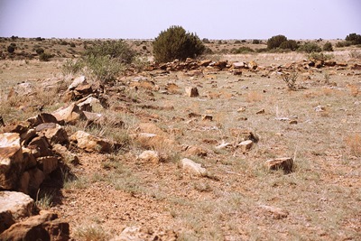
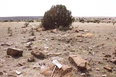
All that marks Camp Nichols are piles of stones.
However, with the ending of the Civil War on April 9, 1865, soldiers were again available to escort travelers over the Santa Fe Trail, and forts began to be constructed to provide supplies and further protection. Fort Dodge was established in April and Fort Aubrey in September. In between, in May 1865, a short-lived stockaded fortification was constructed near Cedar Springs on the Dry Cimarron. This was Camp Nichols, which may have taken its name from Captain Charles P. Nichols of the First California Cavalry.
Camp Nichols was supposed to be in New Mexico Territory, but ended up in what was then mapped as "Public Land" or "Public Land Strip," three miles northwest of present-day Wheeless, Oklahoma. This area, which was home to the nomadic tribes of the Great Plains, was later referred to as "No Man's Land," and wouldn't become Oklahoma Territory until May 2, 1890.
Little remains of the camp now, which was built by Carson at the order of the Military Command of the New Mexico Territory. Intended to be roughly at the halfway point between Fort Union in New Mexico Territory and the Cimarron Crossing of the Arkansas River, not far from Fort Dodge, Kansas, the camp’s sole purpose was to protect travelers from Kiowa and Comanche raids on what had become the most dangerous part of the Cimarron Cut-off.
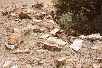
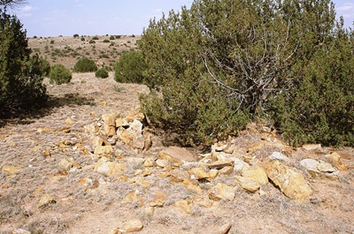
The remains of what may have been lodging for a soldier.
Carson, however, liked the high ground at a location beside South Carrizo Creek, about four and a half miles east of the boundary of New Mexico Territory. Here was built a commissary, two-room hospital, kitchen, and officers' quarters, all dug into the ground and enclosed with rock. These would be the only manmade structures ever built along the Cimarron Cut-off during its active years. Two mountain howitzers stood at the edge of the camp. It was garrisoned by three companies from Fort Union who escorted travelers to Fort Dodge on the Arkansas River or Fort Larned, which was also in Kansas, offered shelter, and generally patrolled the trail.
In fact, following a biweekly schedule, troops from Fort Union also escorted wagon trains east to Camp Nichols, at which point Kit Carson’s soldiers would take them onward. When heading west, Carson’s troops would take the trains from Fort Dodge to Camp Nichols and then hand them off to the men from Fort Union.
This photo was taken from approximately the spot where a map indicates Kit Carson, who was in declining health and would be dead within three years, pitched his tent. It's facing the ruins of quarters occupied by Lieutenant Henderson and Lieutenant Richard Russell, who lived here for a time with his new bride, Marian Sloan Russell. You can read about Russell's experiences in her book, "Land of Enchantment: Memoirs of Marian Russell."
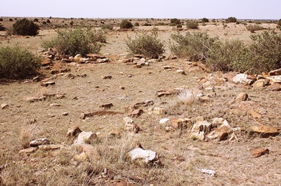
The dimensions of Camp Nichols have been given as 200' x 200' or 200' x 300', the latter of which would have to include some of the structures outside the square boundaries of the fortified camp itself, such as the officer's quarters and the kitchen. But however you look at it, Camp Nichols was not very big, and was never a true fort. It didn't last long either. In mid-October 1865, the Apaches, Arapaho, Cheyenne, Comanche, and Kiowa signed the Little Arkansas treaties and, in exchange for peace, were given a large reservation in the Texas Panhandle. The Texans themselves would refuse to honor this agreement and a new treaty would eventually be required.
But in November 1865, a mere seven months after they’d established Camp Nichols, the 300 California and New Mexico troops stationed there abandoned it and marched back to New Mexico Territory. Local tribes destroyed the camp over the winter, and the site has been unoccupied ever since. In 1966, it was placed on the National Register of Historic Places, but most days is visited only by the wind and perhaps a few cows.
It takes a little imagination to reconstruct Camp Nichols.
A big thank you to the Cimarron Heritage Museum based out of Boise City, Oklahoma, who offer a wonderful tour of this part of the Santa Fe Trail. They provided access to this location, which is on private property, and a number of other rare Santa Fe Trail gems. They do it every June, so if you're interested, get connected with them HERE.
The museum also collected some excellent historical information, including a hand-drawn map, for a handout on the site, which is otherwise spread across numerous sources. Another resource was “Window on the Past: Historical Sites in Oklahoma” by Kent Ruth, which reported the size of Camp Nichols, possibly incorrectly, as 200' x 300'. However, the most scholarly account, and one which adds the most historical context, was found on page 127 of “History of the Cimarron Indians.” This obscure volume was unearthed at the National Cowboy and Western Heritage Museum in Oklahoma City, which has an incredible western history archive. I thank them for their assistance (and for being willing to take a copy of my own book for the archive!). I highly recommend a visit to the museum itself, but you’ll need an appointment to see the archive.
Other useful Camp Nichols references include The Encyclopedia of Oklahoma History and Culture (for both the camp and No Man's Land), The Historical Marker Database (only it wasn't really a fort), Santa Fe Trail Research and, of course, Wikipedia.
Whew. That was a long one! So I'm going to leave it at that for now, except to say that I took all the photos with Fujichrome Sensia 100 35mm color slide film that expired in December 2004. Weird, huh?
