Let's take a trip to the San Jose Mission at San Acacia, 14 miles north of the town of Socorro, in sprawling Socorro County, which spans a chunk of the central part of New Mexico. San Acacia—originally (and sometimes still locally) known as San Acacio—was established around 1880 when the Atchison, Topeka & Santa Fe Railway came through. In “The Place Names of New Mexico,” Robert Julyan notes that the name of the village may have come from San Acacio (aka Saint Acathius), a Roman soldier said to have been martyred with 10,000 other soldiers in the 2nd century A.D. In New Mexico, San Acacio can be found in the work of some santeros on a crucifix wearing the uniform of a Spanish soldier.
When the post office opened in 1881, the “o” had become an “a,” probably because the Spanish was misunderstood. (Note that "San" did not become "Santa.") As far as I know at this moment, the post office remains in operation, but on the west side of I-25, adjacent to the village of Alamillo. Incidentally, an alternative and, Julyan implies, less likely explanation for the name, is that it derives from the acacia bush. If you want to feel like you know the area, go ahead and refer to it as “San Acacio.” You may have some interesting converations!
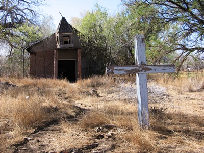
The mission church may still get some unofficial use.
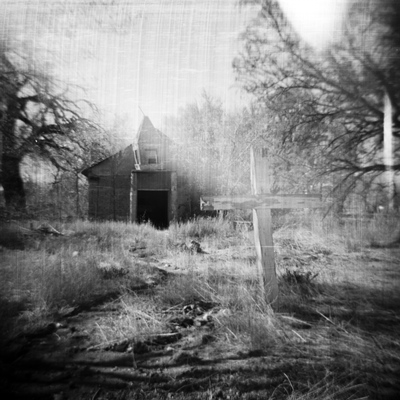
After a flood in 1886 destroyed the church in nearby La Joyita, an adobe mission church with large vigas was soon built in San Acacia, which also sits close by the west bank of the Rio Grande. About 40 years later the historic flood of 1929 sent residents fleeing for their lives, destroying much of the village, and washing the church away. A section of the village dating from the early 1900s is said to have survived the flood and can be seen to the northeast of present-day San Acacia, but I haven’t gone hunting for that.
A few years after the 1929 flood, through the donations of the Crabtree family, who operated a lumber yard and hardware store, the mission church was rebuilt. That one was destroyed in a flood in 1937. So for the next ten years the people of San Acacia went to the church in Alamillo, a bit farther from the river and presumably generally drier. The current mission church was built after WWII and used officially until 1957. Based on what I’ve seen it may well be used unofficially to this day.
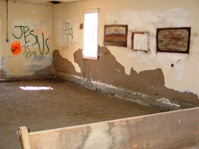
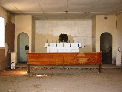
A little artwork has been added to the adobe walls.
In all the years I’ve been visiting San Acacia and posting photos of the mission church (and its likeness in the nearby cemetery; see below) I’ve never heard from anyone that was there when it was having services. Until recently, that is! The recollection I received is so wonderful that I'm going to include it here in its entirety. Memories such as these are hard to find, and I'm always honored to receive another. Many thanks to Ed Baca for sharing his remembrance of a fiesta vespers service:
"I am indeed familiar with the San Jose Mission in San Acacia. My dad's job with the U.S. Geological Survey involved measuring the flow of the Rio Grande on a daily basis. One of his work sites was the gauging station just below the San Acacia dam. As a kid (I was born in 1945), I would often accompany him to San Acacia during my summer vacation. We would pass by that church on the way to the river. While he did his steam-gauging thing, I angled for channel cat at the river's edge.
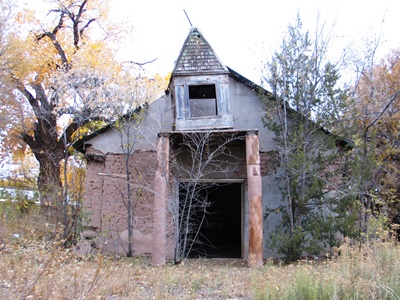
The church has now passed many falls without congregants.
"As a student at Hilton Mt. Carmel School in Socorro, I served Mass as an altar boy at San Miguel Catholic Church. The spiritual needs of the mission churches in the Socorro area were served under the auspices of the Pastor at San Miguel. Besides the occasional funeral of a community member, small missions like San Jose only had one major service during the year, and that was on its namesake's feast day, i.e., its fiestas.
"Around 1957 or so, I, along with another altar boy, and the San Miguel organist and two choir members, accompanied Father James McNiff to San Acacia to celebrate the San Jose fiesta vespers service. The mayordomos and the community's faithful had lighted the path to the church with luminarias. The organist, my aunt Helen Baca, cranked up the old pump organ at the back of the church. The two choir members sang traditional Spanish hymns to an overflowing congregation of current and former residents who sang along with them.
"The memory of this occasion warms my heart to this day. I know that you know that this unique aspect of New Mexico's Hispanic culture is slowly vanishing, and it is sad. But, thanks to efforts of people to preserve the story of a once-vital place, all will not be totally forgotten."
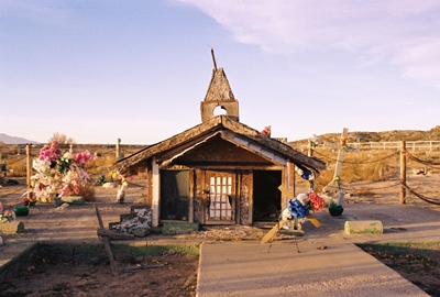
A likeness of the mission church marks a grave in the cemetery.
A short hike from the moody cemetery, which features grave markers representing both the San Jose Mission and the mission church at Alamillo, and right beside the Rio Grande, is a feature known as Black Butte, where the New Mexico meridian intersects the principal baseline. Placed here in 1855 by John W. Garretson, a U.S. government surveyor, this is also known as the “initial point,” on which land surveys for New Mexico and southwest Colorado are based. The rocky surroundings of the "initial point" are said to be the preferred home of more than a few rattlensakes, as well.
This area was also where the Piro Indians lived. Juan de Oñate, the Spanish conquistador, encountered them in 1598 as he came north with his expedition. The Piro would scatter during the Pueblo Revolt of 1680 and never return to their former home, but evidence of their Puebloan culture can still be found along the Rio Grande.
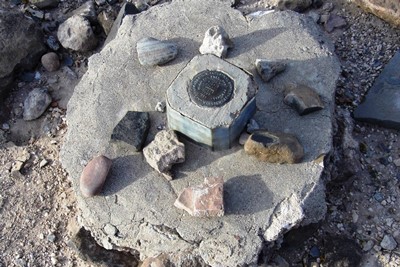
If you could read any of the markings on this monument, you'd find "initial point" among them.
Finally, I would be remiss in not mentioning Acacia Riding Adventures, which runs horseback trips out of the old San Acacia schoolhouse, right across from the church. That sounds like a fantastic way to explore this section of Socorro County, and just a lot of fun in general. You can find more info at their WEBSITE.
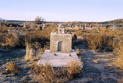
This grave is marked by a representation of the mission church at Alamillo, which was built in 1928.
I grabbed some information for this post from Paul Harden’s excellent “Mission Churches - Part 2: The Mission Churches in Socorro County." (There’s a Part 1, as well!) You can find a little more about the intricacies of the New Mexico meridian and baseline at WIKIPEDIA.
Alright, that’s all I’ve got for this, the THIRD new blog post since…well, October of last year. But that’s better than the last couple years combined! Thanks again to Ed Baca for his generosity in allowing me to share his story far and wide. I think maybe we’ll go to Cabezón, in the Rio Puerco Valley, next time!