
I think I'm going to back off a bit with a couple "family-oriented" posts. Don't worry, there's plenty of danger yet to come, but I'd like to get some photos of the Augusta Canal up, hardly a gritty topic. Or maybe it is kinda gritty. Anyway, Augusta might be even more desolate than it is now without the canal. Built in 1845 by Augustan Henry H. Cumming, it gave Augusta an economic out when the surrounding land could no longer support cotton or tobacco cultivation.
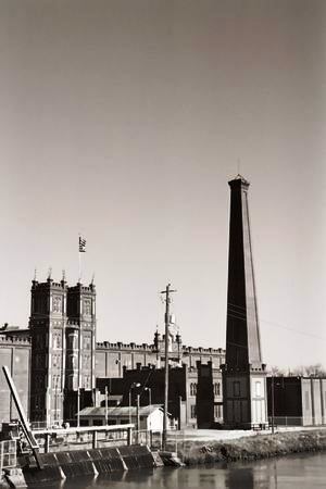
In 1875 the canal was widened for industry, largely by Chinese immigrants who stayed in Augusta and formed one of the few Chinese communites in the South at the time. Working for the mills back in the late 1800's meant working for the man and the man was going to bleed you dry.
 Children began working in the mills as early as age seven and days could be 11 1/2 hours long. This is back in the days before air-conditioning, ventilation in the mills was poor, and inhaling textile fibers might take years off your life. If you didn't like it you didn't work and good luck finding a job anywhere else. The mill companies generally owned the houses of the workers and when workers tried to organize they were soon out on the street. I hope I'm not giving Wal-Mart any ideas.
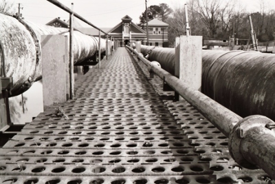
Augusta has gotten it's drinking water from the canal since the canal's contruction. This pumping station was built in 1892 and replaced an even earlier one. The canal generated enough power to make Augusta the first southern city with streetlights and electric street cars. There's a darn good mountain bike trail just off to the right of this photo.
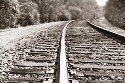
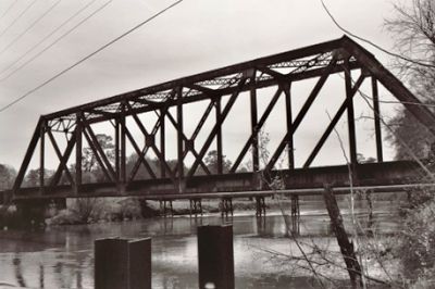
Where there's a canal there's bound to be train tracks. These tracks are still in use, although no longer carrying much product from the mills. The trains are a frequent obstacle while trying to get to the aforementoned mountain bike trail. Also, as far as I could tell, they're routed through the poorer neighborhoods right around the morning and evening rush hours. Pretty wise, that, since everyone knows poor people are never in a hurry.
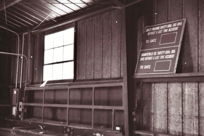
 These two pictures are from the inside of what I think was a little dispatch building for the trains, although I don't know for sure. Pretty much everything along the canal began to fall into disrepair in the 1970's. Apparently there was almost no activity along the water. At least none that was legal. The future didn't look bright, but citizens wanted to preserve the area for recreation and worked hard to keep developers from doing their thing. For once the developers were put-off and the ball really got rolling in 1989 with the creation of the Augusta Canal Authority. Now its one of the most popular jogging/biking/dog-walking areas in the city, a museum has been built, and interpretive boat tours were started in the summer of 2004.
For centuries Augusta was frequently finding itself underwater. The contruction of a levee eased the problem and the canal was straightened in the 1920's and 30's, when spillways and taller embankments were also created. Even so, you can still find odd things in the river bottoms. There's lots of housing going up on the river banks, a testament to people's faith in modern engineering. They just better hope there isn't one of those 500-year floods that happens every 30 years. Additional information on the canal can be found here.

5 comments:
Hi, I found your blog searching for information on the little house in between the railroad trestle and a pipelin walkway across the canal. Do you know what the house was used for and if one can go inside it to take photos. I live near downtown Augusta and have photographed the building numerous time, so am quite curious about the building and its former use. Thanks. Your blog is quite interesting and has given me some information about the area that I didn't know. Your blog name is quite appropriate.
Hi Lynne,
Are you referring to the brick building that looks like a house? The one in the fourth photo from the top in the post? I believe that's the old pump house, used to regulate the water level of the Savannah River. Let me know if that is the building you're referring to and I might be able to get you a bit more information.
Thanks for your comment!
JM
(Note: Lynne was referring to a similar but smaller brick building on the OTHER side of the canal.)
Peter Hughes, who runs an excellent site on the lost city of Hamburg, South Carolina, and knows an immense amount about the history of the area, had this to say:
"Yes, that building originally housed an electric pump. There is a broken down substation on the back side of the building, I guess it used a fair bit of power. The large part of it is not used, the small lean-to on the canal side of the building was and still may be Brian's office, who serves as the "Park Ranger" for the Canal.
The Department of the Interior prepared a Historic American Engineering Record for the Augusta Water Works. According to Page 8 of HAER GA-16, one 700HP electrically powered centrifugal pump was installed in that building. A second pump of the same kind was purchased, but it is not clear where that one went.
Anyway, the purpose of these was to help keep up if one of the water turbine pumps needed maintenance, and the electricity was preferably used at night when rates were lower. I am looking at a copy of the HAER in 'Augusta Georgia' the Canal by Jonathan R. Covington, available through AbandonedHistory.com."
Hope that helps, Lynne. Thanks, Peter!
John
If you haven't already, check out whatwasthere.com which overlays dated photos of buildings and other landmarks against what looks to be Google's Street View. The site isn't too heavily populated, but it's a pretty neat project and also helped me locate Sibley Mill and a few other locations you've blogged about.
Hey, whatwasthere.com is cool! I had no idea it existed.
Thanks very much! JM
Post a Comment