It’s time to head south out of House, New Mexico, drop down off the Llano Estacado, and into the town of Taiban, home of one of the most photogenic churches I’ve ever encountered. From there, we travel Highway 60 west for quite a stretch, past Fort Sumner, Yeso, Vaughn, and Encino. But then, five miles past Encino, we find Negra. So, at the gravel road, let’s turn south and have a look.
Negra, in Torrance County, was established, as were a number of other towns along Highway 60, when the Atchison, Topeka, and Santa Fe Railroad (AT&SF) constructed the Belen Cut-off. This enabled trains to pass through the flat plains and avoid climbing into the northern mountains through Raton Pass. The cut-off came through about 1905 or 1906 and Negra’s post office was established in 1909. However, the post office didn’t last long. It shut down in 1918 with mail to those few still in Negra even then going to Encino
There are a couple stories about how Negra (“black” in Spanish) got its name, including one about a black dog hanging around the early townsite. Robert Julyan suggests the town got its name because of the black soil in the area and mentions the presence of a black water tank. The tank is notable because Negra must’ve had good water and plenty of it. For instance, Encino once got their water from Negra. I was told that a man named Tenorio used a small tanker truck to haul water to town and sell it to the residents. Of course, the steam-powered locomotives would’ve stopped in Negra to get water, as well. After the conversion to diesel engines, Vaughn bought four wells near the tracks from the railroad and, at some point, even Duran, 20 miles away, got water from Negra.
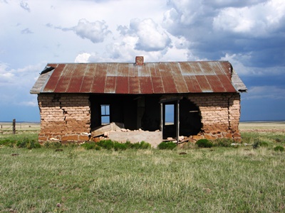
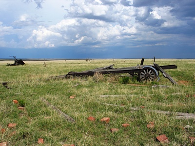
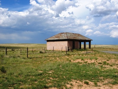
Beyond the above, there’s not much information available on this little town. Nearest the highway is a vacant but nicely intact filling station that might be from as early as the 1920’s. It’s pictured below. (Note “U.S. POST OFFICE” written near the roof. Perhaps this was salvage material.) Behind it is an old tourist court. Both were built by C.E. Davenport, Negra’s first postmaster. A working ranch--the Davenport Ranch--is adjacent to the south. Even farther to the south, across the still-active railroad tracks, there’s a cemetery. To the west, where most of the community once was, only a couple buildings remain. Two, which are not much more than piles of sticks now, were an old school and a teacher’s residence. An adobe structure with a big hole in the middle (shown above) might’ve been a more recent school.
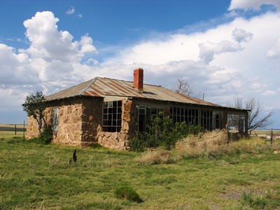
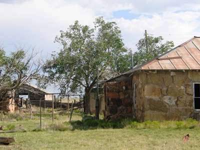
But the gem of Negra is the wonderful rock house, built on the site of an old grocery store, and its attendant barn and outbuildings. Despite the paucity of historical documentation, in a happy twist of fate it’s known who once called this lovely place home. In my post on Encino, I mentioned that there were once four beautiful murals on the walls of the high school gymnasium, which had sadly been torn down. Those murals were done in the very early 1940’s by Hallie Williams, and it is she and her husband Albert (nickname "Ollie") who lived here. Hallie also painted at least one other mural and I’ve been told it still exists, in a store built by Mr. Williams in the 1950’s, also in Encino.
Mr. Williams ran a filling station in Negra—likely the vintage one just mentioned. He also operated a mercantile that fronted the railroad tracks in Encino. This store contained a reportedly very smelly stuffed buffalo head on a wall. Later, in the mid-1940’s, Mr. Williams built a smaller store on the north side of Highway 60. His third store in Encino, then, would be the one containing the mural.
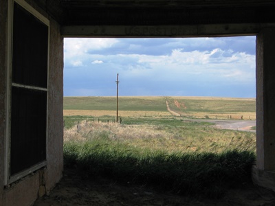
Now, there are some abandoned places that legitimately feel creepy and leaving them brings with it an undeniable sense of relief. Then there are other locations, like the Williams’ homestead, that are peaceful, if not downright soothing. With the sun and clouds playing across the flat land of the eastern plains and a cool breeze rustling the grass, I could’ve stayed there—and, indeed, in all of what remains of Negra—for many more hours than I did. I hope to return soon. I feel like there’s more to be learned out there.
About the only published documentation of Negra that I’ve come across is Dixie Boyle’s "A History of Highway 60 and the Railroad Towns on the Belen, New Mexico Cutoff” It’s a fantastic source for all kinds of info on the towns along the highway. Of course, Robert Julyan’s “The Place Names of New Mexico” handled the naming story, per usual. I even got a few facts, particularly about water, from comments left on the City of Dust Facebook page. Finally, Henry R. sent me a fascinating message about Encino and Negra, as well as background on Mr. Williams, his various stores, and his buffalo. As Henry R. was there back then, his is a fantastic first-person account. His full letter can be read as an update on my post on Encino, which I first published in 2013. Photos of Hallie Williams' now-destroyed murals can be found there, too.
Alright, we won’t have far to go to get to Lucy, the next stop on our never-ending journey.
DECEMBER 2014 UPDATE: As she did by contributing her photos of Hallie William's murals to my post on Encino--the only known shots of those murals, I might add--Dixie Boyle has significantly increased the worth of this post by sending in two great old photos and providing a bit more information on Negra, and the Williams family, in particular:
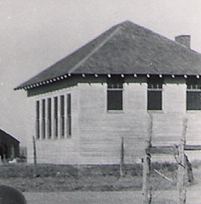
"Hallie and her sister, Carrie Walker, taught at the Negra School (pictured below) when it was first built, and then in later years Hallie taught music and art classes at her house, which was across the road from the school. The kids would walk across the street to her home for classes. The pile of wood in the middle of the others was the Negra School. During this time the kids made up a wonderful puppet show that Hallie and her students took to other schools. Her daughter, Carrie, still had the puppets when I interviewed her.
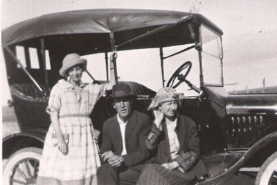
"Carrie and Hallie actually moved from Texas to Negra to homestead land together. They built a shack to the south of the school somewhere. Ollie also moved to Negra to homestead. Hallie had a degree from Baylor University and had taught in Texas a few years before arriving in Negra. You can find Hallie and Ollie in the Encino Cemetery.
"In front of the car (above) it's Carrie, Ollie, and Hallie. I just love this picture of them."
Many thanks to Dixie Boyle for yet again providing photos and information that are nearly impossible to find elsewhere. The best place to get this stuff is directly from Dixie's books, in this case, particularly "A History of Highway 60 and the Railroad Towns on the Belen, New Mexico Cutoff", which would almost surely be of interest to anyone reading this post.

10 comments:
I have to agree with you that it seems like a peaceful place! Absolutely gorgeous! Reminds me of the prairie in Kansas/Oklahoma, but maybe even prettier. Thank you for sharing. :)
I really did enjoy my time there, Shannon Wallace. I tried to capture the peacefulness in my photos, but getting that essence is always a difficult thing to do.
Anyway, thank you very much for your comment. I'm glad you liked the post! JM
There is a feel of peace and contentment in some lonely places, in others despair and confusion. Generally I gravitate to the peaceful places, but then again maybe I just see them differently from others. Ft Sumner is quiet, but with an undercurrent just below the surface.
You may already have visited this site, if not it might be of interest:
http://newmexicohistoricalmarkers.blogspot.com/
You might also like this publication in PDF form about Arizona historical markers: http://azmemory.azlibrary.gov/cdm/ref/collection/statepubs/id/10100
CoastConFan, I guess one person's peace and tranquility is another person's depressing wreckage! Although, like you, I find some places to be much more despair and confusion than peace and contentment. Ft. Sumner does have an undercurrent about it that even Yeso and Taiban don't.
Speaking of which, I was just reading in El Palacio magazine about a guy who went out to find the cabin in which Billy the Kid and Charlie Bowdre holed up in while Pat Garrett waited outside. Garrett, of course, shot the wrong man, Bowdre. The location was found and the foundation stones were plain to see. It's out by Taiban. Another site for the to-do list!
I didn't know about that historical marker website, although I know the fellow that wrote the guidebook to the signage. That would be THIS ONE.
I hadn't come across the AZ catalog PDF, so thanks for that.
Best, JM
You could do a sort of Billy the Kid trail, starting with Silver City and the foundation of the cabin there as well as his mother’s grave in Catherine McCarty. Ending it with the house he was shot, 14 July 1881 at the Lucien Maxwell’s house near Ft Sumner, which was owned by his son Pete Maxwell as Lucien died back in 1875. You could call it “The Foundations (Literally) of The Billy the Kid Story” Everybody has done the standing structures to death, but nobody has one a photographic roster of vanished buildings of Billy the Kid.
I found this reference “The Maxwell house where the kid was killed is near there but is marked as it fell into the river long ago in a flood.” It probably explains why I don’t remember the place. Here is an article to find the Maxwell House: http://wikimapia.org/22429100/Maxwell-House
You reference to the Taiban shack is another good lead and I presume it is in Stinking Springs. You also have Blazer’s Mill for another important foundation to be covered. I like the ideas of just covering the ruins, which comes under your ghost town ideal and leave the standing structures as being too easy.
The Alexander McSween place was the site of a furious battle and was burned, so would make another likely place for the roster. The historical marker makes this one easy.
According to Wikipedia “In November 1880, a posse pursued and trapped McCarty's gang inside a ranch house owned by his friend James Greathouse at Anton Chico in the White Oaks area” Any idea where that house is at and is it still standing?
CoastConFan, your comment is timely as the most recent issue of El Palacio Magazine has a feature by a fellow that went looking for the remains of the cabin that Billy the Kid and Charlie Bowdre holed-up in before Bowdre was shot by Pat Garrett (who thought Bowdre was Billy the Kid). That is the Stinking Springs cabin near Taiban and, by talking to some locals, he found the location. Just a few rocks around the foundation were left, but you could see the outline. It was a fascinating article and I really want to have a look for myself now.
As for the location of the Maxwell House, I did manage to stumble on that in Ft. Sumner. HERE'S A PHOTO of the marker they put in at the spot where Billy the Kid was shot. I imagine it's just a generic point where the house was and not the precise location at which he fell. The marker sits in some gravel and clumps of grass by the Pecos River.
I'm not sure exactly where Blazer's Mill would've been, nor the ranch near White Oaks. I'd like to know though! I did have a look at the graves of Tunstall and McSween behind Tunstall's store in Lincoln once.
I've been considering a Billy the Kid-related post for a couple years now and even assembled a bit of material, but it's so daunting that I kind of want to save it until after I've worked through my current backlog of posts.
I should mention that I have also been to the Billy the Kid Pageant in Lincoln. Now, *there's* an interesting slice of Americana!
As always, thanks for the fascinating comment! JM
I’ve driven past the Blazer’s Mill marker a good number of times on the way from Alamogordo to Ruidoso and back. It’s near Bent, NM (pop just over 100) on US Hwy 70. Go to Tularosa and then turn off of Hwy 54 onto Hwy 70 towards Mescalero and you’ll see the sign for Blazer’s Mill. If I recall, the Rio Tularosa (Tularosa Creek) runs right next to the road and if you look to the south side of the road, you can see the ruin.
Here’s a blog entry about Blazer’s Mill and the sign:
http://newmexicohistoricalmarkers.blogspot.com/2014/06/blazers-mill-historical-marker-lincoln.html
Mapquest shows it here, near Mill Drive, a little over a mile outside of Mescalero http://www.mapquest.com/maps?city=Blazers%20Mill&state=NM
Yeah, I’d been to the Billy the Kid Pageant way back when, when my wife set up selling silver jewelry there. It’s kind of a funny town, it seems incomplete somehow or at least lots of unfinished business went on there – hard to describe, although I have been to Lincoln a dozen times at least. In fact, it was via Hwy 54 to Hwy 70, right past the Blazer’s Mill marker, then up to 380 was the general route to visit Lincoln, As for the possible Billy the Kid post, take it chunks if it runs too big; only snakes swallow whole.
I know one reason why I wasn't familiar with Blazer's Mill--I've never driven that stretch of Highway 70 between Tularosa and Mescalero, CoastConFan! There was a very interesting You Tube video showing the ruins embedded in that NM Historical Markers page. There's a lot left standing. I really need to check it out.
Lincoln is kind of an odd place. I spoke to someone there that was telling me about some strange feuds and conflicts between residents. I guess the more things change the more they stay the same.
Well, guess I better get on the road and see this stuff soon! Thanks for the tips! JM
http://www.findagrave.com/cgi-bin/fg.cgi?page=gr&GRid=50262912#.VaPVoAao0sQ.facebook
Hmm, Delayne Gravelle, that grave might be hard to find in the Negra Cemetery: "Note: no headstone was ever placed on Ephriam Vestal's grave." Do you know much about Ephriam Allen "Doc" Vestal? I really don't. Perhaps a relative of yours?
Thanks for your comment! JM
Post a Comment