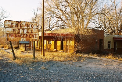
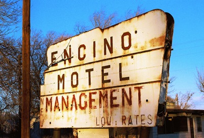
I spend a lot of time on US Highway 60. Not only do I travel the road for work, but I often explore its lonelier byways on my days off. Highway 60 once crossed the entire country and in New Mexico these two lanes of blacktop run through the central part of the state, from Texico to Quemado. US-60 essentially parallels I-40, but it’s usually at least 50 miles south and will take you maybe 5 times longer to travel. Sounds good to me! As one of my favorite stretches of asphalt anywhere, we’ve already visited some places along its route: Taiban, Yeso, Mountainair, and Pie Town among them. So, it’s high time to check out another: the mysterious Encino.
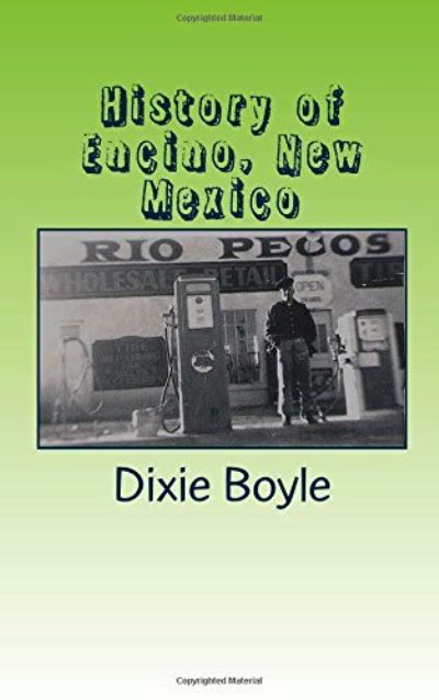
If you drop “Encino” into your Google search engine about all you’re going to learn is that the population was 94 in 2000 and the town encompasses all of 2.0 square miles. Luckily, Dixie Boyle apparently likes Highway 60 as much as I do because she wrote an entire book about the New Mexican portion. Aside from the above facts, which are straight from Wikipedia, everything else in this post is from “A History of Highway 60 and the Railroad Towns of the Belen, New Mexico Cutoff.” Thanks, Ms. Boyle!
The name Encino, which means “oak” in Spanish, was derived from the scrubby trees that once covered the central plains of New Mexico. As is so often the case, Encino’s location can be traced back to a spring, long a well-known stop for thirsty travelers. Prior to 1900, something like a fort was built nearby to accommodate the dusty and weary for an evening or two.
Bonnie Salas was the first to homestead the land that would become Encino and, at that time, the few people in the area were mostly raising sheep or cattle on a fairly large scale. In 1905, the railroad announced plans to establish a depot in Encino and people took notice. This was another common story out on the plains, and one that usually ended similarly, as we’ll see.
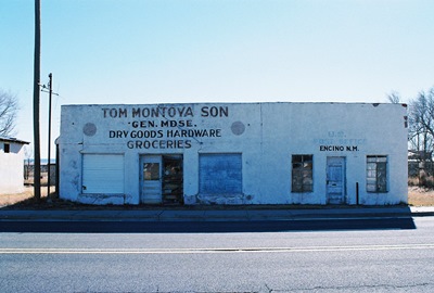
The Bond family bought 40 acres from Bonnie Salas, some of which they’d soon sell to the Atchison, Topeka, and Santa Fe Railway for the depot. That same year they also built the B.G. Bond Mercantile, which doubled as the depot for a bit and remained the only store in Encino until A.R. Cecil established a lumber company in 1908.
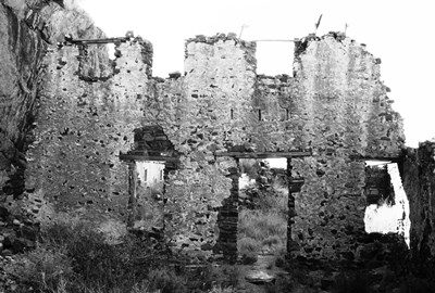
Encino’s post office opened in 1904 and both a Protestant and Catholic Church were built in the town, at least one of which doubled as a school. In 1910, the Encino Progress newspaper was founded and quickly went out of business. The Encino Enterprise gave the newspaper trade another shot in the 1920’s and managed to hold on for about a decade. Somewhere in there William’s Mercantile was built along Railroad Street and was later moved to abut Highway 60. Unfortunately, I arrived just a few years too late to photograph the long-vacant store.
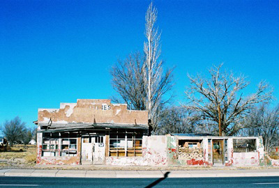
The best known citizen of Encino is undoubtedly R.C. Dillon, elected the eighth Governor of New Mexico in 1927. While Governor Dillon was born in St. Louis and moved to Springer, NM when he was 12, he later worked at B.G. Bond’s Mercantile and eventually opened his own store, R.C. Dillon & Company. The building is said to still be standing and recognizable by its faded sign. But for some reason I didn’t see it. Maybe it, too, is now gone.
Dillon served two two-year terms and would sometimes have political friends over for dinner at his home in Encino. The Governor was also a big proponent of paving roads. Not a surprising interest to have given the muddy, bumpy tracks he would’ve had to travel. Highway 60 was originally a wagon route and it wasn’t until 1918 that it began to see some initial truck traffic. Even once cars became relatively popular, horse and buggy was often still the faster way to travel the area. While US Highway 60 was officially designated in 1926, parts of the route in New Mexico actually remained unpaved into the 1950’s.
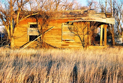
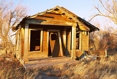
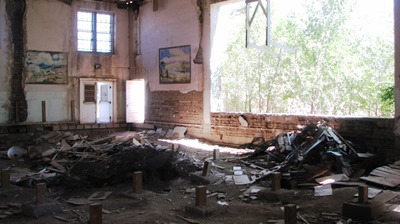
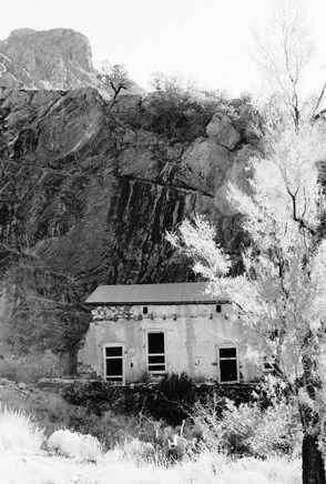
In 1965, Encino’s railroad depot closed and few small towns could weather that blow unscathed. The high school closed in 1982 and many of the town’s adobe buildings are now melting back into the earth. However, it’s said that the old Works Progress Administration-built gymnasium still contains the southwestern-themed murals of Hallie Williams, which she painted for $20 a pop between 1939 and 1942. On my next trip through I may need to see if I can track those down. Can anybody confirm that they’re still there?
So, that’s about all I know about Encino. If you’ve got stories or recollections to pass along, please do! Clearly, much of Encino’s history is fading fast. Next time we’ll go just a few miles east and have a look at Encino’s bigger neighbor, Vaughn.
JUNE 2013 UPDATE: I'm pleased to report that Dixie Boyle, whose excellent book on US Highway 60 is referenced above, got in touch with me to provide the latest on the murals in the Encino gymnasium. Unfortunately, the news is not good. Here's what Ms. Boyle had to say:
"The murals are probably no longer standing. The last time I went through there, maybe five-six months ago, the town was tearing down the old gymnasium and school. They had half of it down and were slowly working on the other half. The half with the murals was still standing. I wanted to save those murals as they were so unique, but by the time I discovered them they were too far gone and would have crumbled if moved. I was surprised no one had thought of saving them before. You could check with the city hall in Encino and see if they are still there."
One of the reasons I started this blog was to document the many forgotten places that have attracted me before they disappeared entirely. So, it's pretty painful to realize that I could've seen the murals for myself if I'd just known they were there. I guess I should've read the first edition of her book, “Highway 60 & the Belen Cutoff: A Brief History”, a little earlier. It might well be worth checking with the city, but I'd be surprised if the murals still exist.
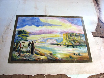
Anyway, below are Ms. Boyle's photos of Hallie Williams pieces, each painted around 1940. They are quite beautiful and I know of no one else that has photographed them. So, I give my heartfelt thanks to Dixie Boyle for sharing these.
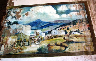
The mural above and the one below were clearly the best preserved of the four murals Hallie Williams painted.
The mural below was already badly damaged several years ago.
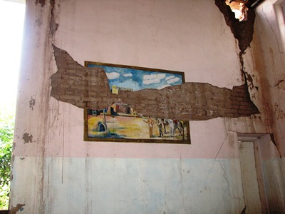
One of the four murals had already crumbled when Dixie Boyle made her visit, so the three above are all that have been recorded. Below you can see the precarious state of the gymnasium and how two murals were placed. Clearly, without expensive preservation efforts, they wouldn't have lasted much longer.
NOVEMBER 2013 UPDATE: I just received a letter from Henry R. that is so interesting that I thought I would post it here. In it, there is reference to the above-mentioned Hallie Williams and another mural that she probably painted which still exists. Hopefully I'll be able to post a picture of that mural here soon. Many thanks to Henry for sharing his knowledge of Encino's history.
"Hallie Williams must be the wife of Ollie Williams that owned a mercantile store on the old main road that fronted the railroad. I remember he had a stuffed buffalo hanging on the wall that stunk to high heaven. He built a smaller store on the North side of Hwy. 60 in the mid '40's. I bought comic book's and candy there. In the early '50's he built the building on the NE corner of Hwy. 60 and Hwy. 3. There is a mural on the inside wall that faces the highway that must have been painted by Hallie as it resembles the murals in the old gym. I have a picture of it somewhere and email it to you when I locate it if you wish. Ollie also owned the old station in Negra that was still standing last year.
My dad Henry "Boots" R. managed the old Rio Pecos Oil Co. station across the street in the '40's and later a Gulf station on the NW corner of Hwy. 60 and the road that leads to the school. In the late '70's Boots bought the Williams station from Ollie and the sale included several acres on the North side of Hwy. 60, the old rock building/store, and the Harrison house.
After Boots death in 1982 I sold the Williams property to "Buttermilk" Dennison who owned the old Rio Pecos station across the highway, excluding the Harrison house which I still own along with six prime highway frontage lot's. I attended school with Kenny Harrison and some of his siblings off and on till 1952.
The information above is as I recall it but may be off on dates."
DECEMBER 2016 UPDATE: Dixie Boyle, who wrote "A History of Highway 60 and the Railroad Towns on the Belen, New Mexico Cutoff," has just published a short book compiling much of what can be learned about the history of Encino. Space is devoted to NM Governor and Encino resident R.C. Dillon, artist and teacher Hallie Williams, and the old stores and gas stations of Encino. A few words are even said about nearby Negra. Oh, and City of Dust gets a couple mentions, too! "History of Encino New Mexico" can be bought on Amazon or, better yet, at the recently-opened Encino Firehouse Mercantile & Deli next time you're passing through town. Of course, I highly recommend getting a copy!
 Despite being from New York, Van Patten joined the Confederacy during the Civil War and served on General Stonewall Jackson’s staff. Once the war ended, he professed himself to be a member of Abraham Lincoln’s Republican Party for the rest of his life. In 1865, he married a high-ranking Piro Indian, Benita Madrid Vargas, and became involved in Native American affairs. Through the late 1800’s, he was everything from a county sheriff to a deputy U.S. Marshall to an organizer of the NM chapter of Teddy Roosevelt’s Rough Riders, though he himself did not ride roughly. Financial problems forced him to sell his resort in 1917 to Dr. Nathan Boyd and his fortunes continued steeply downhill from there. He died nearly penniless on February 28, 1926 at the age of 86.