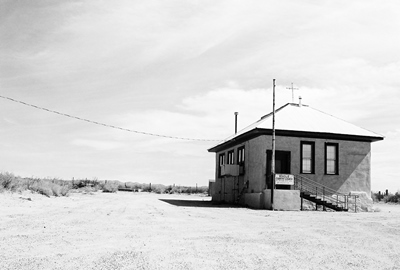
There’s not been much written about Engle, New Mexico over the years. The usual ghost town books I consult only mention the town in the context of its stage and rail connections to other places. But Engle, now not much more than a handful of buildings persisting in the relentless heat of a dusty former rail stop 20 miles east of Truth or Consequences, sits within an area that has played a major role in the histories of Spain, Mexico, and the U.S. Currently, it is the home base for an enterprise owned by a well-known cable television magnate and, in the future, may be passed through by some very wealthy people on their way to…orbit.
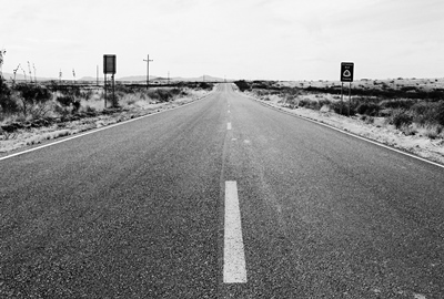
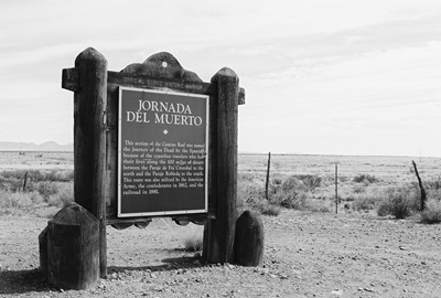
It makes sense to start the story of Engle with the Jornada del Muerto, the “Journey of Death,” which runs through the town. Or, perhaps, a couple hundred feet west, if you want to get technical. Considered the most treacherous part of El Camino Real, this stretch, beginning slightly north of Las Cruces, traversed a desolate wasteland devoid of water, firewood, or shelter. So, if the Apache didn’t get you, the desert itself might. Just imagine traveling over an ancient lava bed by horse in the early 1600’s without a Wal-Mart or 7-11 in sight. It might sound like heaven now, but let’s not romanticize too much. The closest city to the north, a long 90 miles away, was named Socorro (i.e., succor, relief, aid, etc.) for a reason. But, all that aside, plenty of travelers did survive the journey and thus, for many years, one of the most important trade routes in the history of the world passed right outside what would become Engle’s front door.
Founded in 1879, Engle was, like so many other towns in the West, born of the railroad. Named for R.L. Engle, the railroad engineer who supervised construction of the line through town, due to a paperwork error Engle was officially known as "Angle" for its first six months. An attempt to rename the town "Engel" in the 1920's, in honor of Atchison, Topeka, and Santa Fe (AT&SF) vice-president Edward J. Engel, was halted in the 11th hour when "cowboy chronicler" Eugene Manlove Rhodes asked Senator Bronson Cutting to pull some strings.
The railroad soon built a station and Engle thrived as a shipping point for cattle from surrounding ranches. Horses, mules, stagecoaches, and eventually trains transported ore east from the more remote mining towns on the edge of the Black Range, including Cuchillo, Chloride, and Winston (then known as Fairview), and from Engle it all moved on to larger cities, such as El Paso. A post office opened in 1881 and the place was off and running.
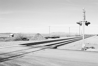
From 1911-1916, the construction of Elephant Butte Dam, about 10 miles west, increased the population greatly. Housing in Engle was convenient and the town was the switching point for the AT&SF spur that carried materials to the dam. The peak at that time was about 500 residents, but with completion of the dam workers left immediately and Engle began its decline. By 1919, 300 people, over half the peak population, had left. Seven years later, only 75 souls remained. In 1945, much of the land to the east and south of town was claimed by the federal government for White Sands Missile Range, snuffing out most of Engle’s remaining light. But not quite all of it.
While the post office closed in 1955, a few people live in Engle yet. The train still rumbles by, however, it doesn’t stop.
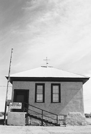 Not many original buildings stand, but one, the old schoolhouse, occupies what would seem to be the spiritual center of town. That’s not just on account of it being the most prominent building you see as you cross the railroad tracks, but because it’s now the Engle Country Church featuring “bible preaching and gospel singing” at 10 AM on the third Sunday of every month. Conveniently, there are some vineyards being tended nearby, too, in case the supply of wine runs low.
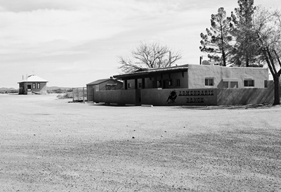
Engle has also become the headquarters of the Armendaris Ranch, a massive 362,885-acre spread owned by Ted Turner of CNN and Jane Fonda fame. Word is that when he comes to town, his entourage lays the necessary groundwork a few days in advance and then Ted blows in, checks on his buffalo, maybe does a little hunting, and is off again. Turner owns two other huge ranches in New Mexico and is the second-largest private landowner in the state.
Moving into the totally surreal, Engle is poised to be a way station for those heading to Spaceport America. Anyone not flying directly into and out of the spaceport or coming up from Las Cruces would be obliged to go through Engle. It is strange to imagine that some of the richest, most famous people on the planet might see Engle shortly before they are launched into orbit for a few seconds. On the other hand, those who traveled the Jornada del Muerto hundreds of years ago might well appreciate the irony. For the dusty little patch of Chihuahuan Desert on which Engle persists has a habit of being a quiet witness to great journeys.
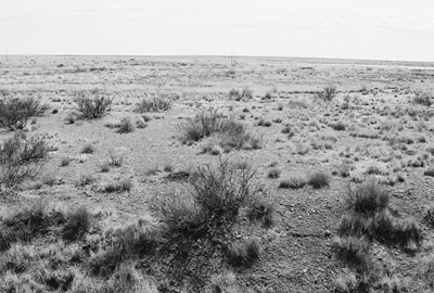
It’s not easy finding information on Engle. The usual physical sources overlook it, but on-line you can find most of what seems to exist at ghosttowns.com. Even Legends of America won’t tell you anything about the town. But they will tell you that, in the 1880’s, Bill Hardin, famous gunfighter John Wesley Hardin’s first cousin, was lynched by a mob after killing a man near Engle. Oddly, the “Ghost Towns of Sierra County New Mexico” promotional card is one of the better resources, even at all of five sentences. NM Place Names recounts how Engle came to be called Engle (and then almost wasn't). Otherwise, Wikipedia will tell you about the Jornada del Muerto and Spaceport America will tell you about Spaceport America.
Next time we’ll cross I-25 and move nearer the Black Range to visit the relatively well-known partial ghost town of Hillsboro, NM. Until then, have a happy 4th of July and safe travels, everyone.
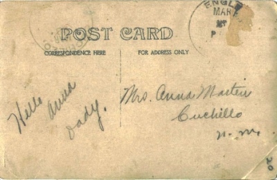
JULY 2014 UPDATE: Mr. William M., former resident and continued aficionado of the wide-open spaces of New Mexico,
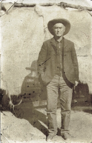 has contributed a very interesting photo postcard. Postmarked from Engle to Mrs. Anna Martin of Cuchillo, NM, William guesses the card is from about 1910. Note the sparse address and even sparser message, which reads, "Hello Anna Dady (sic)." The few words speak volumes about this time and place. We can only assume that the stoic desert fellow pictured is indeed Anna's father, probably captured by a photographer traveling through Engle. William adds, "It was sent from one ghost town to another ghost town – only in New Mexico."
Thanks for the great addition, William!
21 comments:
Great write up on one of the most desolate, semi-inhabited places in NM. One of the great horrors of being on El Jordana del Muerto was having to die of thirst right next to the Rio Grande (Rio Bravo) because it is deeply recessed into a very steep canyon. It’s my understanding that a trip from Mexico City to Santa Fe took nearly a year by oxcart. That is why Santa Fe was considered the end of the world in Spanish colonial times.
The road that runs west out of Engle, Hwy 52 , was gated in WWII because it runs through a military reservation. Were you able to drive completely down the road, through the pass at Big Gyp Mountain, you would be at Holloman AFB, just slightly north of White Sands, there in the Tularosa Basin. It’s a funny place itself with a beautiful gypsum sea of sand and just right north a large and fairly recent (geologically speaking) lake of black lava. Salt and pepper NM style.
This map of New Mexico lava fields gives a perspective about how extensive the lava beds lie above the surface. http://www.nmnaturalhistory.org/volc_caballo.html
Thanks, CoastConFan! Glad you liked this one. Is that Hwy 51 heading EAST out of Engle that you're thinking of? That road being shut and gated in the mid-1940's, was, of course, very problematic for Engle, effectively cutting off any reasonable entrance to the town from the south and east.
I'd love to one day be able to travel the old roads through White Sands Missile Range, but I know better than to hold my breath. It must be like driving back in time out there, through places, albeit never much populated, that very few people will ever see now. Of course, with all that lava to traverse, some people probably never wanted to see them again anyhow.
Thanks again! JM
Headed east out of Engle, right you are. BTW I always carried a compass along with road and topo maps. NM is no place to get lost in the back country.
From what I can see, the road or a branch runs through the mountains and appears to connect to the road near Holloman High Speed Test Track if Google maps is correct. I'd hate to drive that without a 4WD truck.
https://en.wikipedia.org/wiki/Holloman_High_Speed_Test_Track
I believe I looked at the same road through the mountains as you did, CoastConFan. If passable, it would be a lonely--and probably bumpy--ride. That's why my next car will be a truck! JM
Great news for followers of this blog: New Mexico author Michael McGarrity's newest series based on his own family features the Engle area.
That's very interesting, blue hole dude. There can't be many stories set in and around Engle. I've not read Michael McGarrity, but I know the name and should really pick something up. I'm a pretty big fan of crime/noir literature.
Thanks for the comment! JM
I worked at site in WSMR in the late 1980's. I had upper range privilege, which meant I could enter through Stallion Gate on the north end, then drive down the "upper range" road to the back entrance of the test site. It was a unique experience, driving down those roads you'd see boarded up range buildings along the way. I always wondered about what projects they were used to support. I know one of the buildings they let us use was just locked up when a project lost funding. There were uncompleted printed circuit boards sitting in vices at work benches, solder irons waiting to be used, bins full of various electronic components.
Maybe some day the average person will have access to these same roads.
Well, deicher, *I'd* sure love to have access to those same White Sands Missile Range roads! That must've been great to be able to kind of cruise around out there now and then. I've heard there are a couple ghost towns on the range. Of course, I'd love to see those, too, along with that building with the electronic components. I've only been to the Trinity Site and the bomb assembly house thus far. And that might well be as far as I get! WSMR seems like a strange and mysterious place...
Thanks for your comment! JM
Yep, WSMR is an interesting place. Having range access was not common for site personnel. They gave it to a group of us from Albuquerque. We drove down every Monday morning, stayed in Cruces M-Th night, then drove back to Albuquerque after work on Friday. The first eagle I ever saw in the wild was sitting on top of a telephone pole along upper range road. Because of range tests we would occasionally get delayed or told to detour. On the way north one Friday we got detoured through Northrup Strip, entered Holloman AFB and exited via Tularosa gate. That was a very long drive home.
I drove past the turnoff to Trinity site many times, but I've never been there.
thanks for your blog
That does sound like a long drive, deicher! Is Tularosa gate near the town of Tularosa? That would put you on Highway 54, which would indeed be a trek back to ABQ. Although it's a drive that I love...assuming I'm not in a hurry.
Visiting the Trinity Site was more affecting than I expected. Some people don't think it's any big deal, but it seemed like a very poignant place to me. Although it's true that at first glance there isn't much to see besides the lava-rock obelisk and some twisted metal. HERE'S a shot of the...fence (and ordnance expert Rear Admiral William Sterling Parsons)!
Glad you like CoD! I really appreciate it! JM
Yep, Tularosa gate is near Tularosa, NM. Yes, it was a very long Friday evening drive home. I just remembered another range test detour, this time it was further north. I ended up driving on range roads that skirted the lava flows. I believe I ended up coming out one of those ranch roads off of US380. It gets pretty lonely on those remote range roads.
It can indeed get lonely out there, deicher. There are also some interesting places along US 380. Conrad Hilton, founder of the Hilton Hotel chain, grew up in San Antonio, NM, which I wrote about HERE. Then there is the former location of Carthage/Tokay/Frailey. Honestly, I couldn't make heads or tails of what was what out there, but I checked a map when I came home and I'm pretty sure we'd wandered onto White Sands Missile Range property. I was pleased no one had decided to ask us about it at the time. I did the best I could on that history HERE. A rather lonely (and nice!) drive near there is the QUEBRADAS SCENIC BYWAY, which heads north off US 380 very near Carthage et al. and thus the Trinity Site. JM
Rhode's ranch as well as Governor Ritch's range were to the east of Engel. My great uncle married the daughter of Ritch in Engel in the 1880's. In 1993 when I was living in LC my husband and I attempted to drive east from Engle and got stopped up in the hills. Nice scenery up there.
Thanks for this information on Engle. My Great Great Grandfather was half owner of the SS Bar Ranch at Engle and managed it onsite for a few years in the late 1890s. The Kansas City Cattle Company was the other half owner. I have been researching Engle to see if I could find the location of that ranch and any other available information. Would appreciate feedback if anyone can point me to a source or contact that might be able to help me. Thanks again.
Thank you for your comments on Engle-area ranches, Anonymous and Unknown! I love to hear about these places! One of the reasons I'm excited about comments such as yours is because I know so little about New Mexico's ranching history. Unfortunately, Unknown, that also means I can't provide any information on the SS Bar Ranch myself.
However, I might suggest that you contact the NM Farm & Ranch Heritage Museum in nearby Las Cruces. They have exhibits, events, oral histories, and more, all about...New Mexico's farm & ranch heritage. I think they may well be able to help you. You can find their website and a phone number HERE.
Good luck! And thanks again, folks! JM
I stopped by after seeing an update for Engle. I have another story related to my WSMR days.
One wintry Monday morning on my way down from Albuquerque I-25 was closed south of Socorro, blocking the path to US380. Being the dedicated employee I decided not to let a little thing like a major snowstorm stop me from getting to work. So I headed west to take the looooong road from Socorro to Las Cruces, which is US 60 to Datil, then south on NM 12, turning on US 180 west of Reserve. Along the way I drove throw Aragon, NM, where I had briefly owned land nearby in late 1970's. Needless to say this was one of the stupidest things I ever did in my life. Driving down US60/NM12 I made fresh tracks on the road, only staying on the road by following signage and mile markers. I finally got to Las Cruces around sunset.
Some of my co-workers knew the local roads around Socorro so they took back roads to get to US380 at San Antonio, proceeding down US380 to Stallion Gate. At Stallion Gate the MPs sopped them from going further until there was a large enough caravan to head south down Upper Range road to site.
I don't see anything about Aragon NM on your site.
Well, deicher, that's quite a story for a day of record snow here in Norman, OK! Not to mention record low temps! I've driven Highway 60 out that way many times, and can imagine what it must've been like. Harrowing indeed, but I do have to admire your work ethic! Was it at least pretty/awe-inspiring at times?
You know, I was once stuck on I-25 going the other direction, heading north after leaving Tucson. Due to a snow and ice storm the interstate was shut just north of Truth or Consequences (before deep, slippery Nogal Canyon), but all I could do was find a place (the Desert View Inn, as I recall) and hunker down for the night. It was quite memorable, at least.
As for Aragon, I'm sorry to say I don't believe I have any photos. I've only driven NM 12 up from Mogollon one time, heading through Reserve and then Horse Creek Springs. I *do* have photos of Horse Creek Springs (and Reserve, for that matter), but I just can't recall stopping in Aragon. That was a mistake. What did I miss?
Thank you for the story! I hope you're driving through less snow this particular week, but, given the state of the country, I sure can't assume.
Be safe! JM
If you blink while driving through what remains of Aragon NM you miss it, https://en.wikipedia.org/wiki/Aragon,_New_Mexico .
Speaking of I-25 and Nogal Canyon, on another slippery event during the same winter a co-worker spun his Toyota MR2 off the road coming south on I-25 though Nogal Canyon. The MR2 liked to spin because of it's nicely balanced mid-engine design. ;-) Shoot, even on a clear sunny day Nogal Canyon can be very dangerous during high crosswinds.
Ah, heck, I guess I must've blinked and missed Aragon! Although I eventually decided I would take at least one photo of every single city, town, village, or crumbling foundation that had a name. So I'm not really sure what happened. I guess I better go back sometime!
Spinning off the road at Nogal Canyon would take years off one's life. That's if it didn't actually *take* your life. Wow. Yes, even with the sun out and not a cloud in the sky those orange wind socks can look ominous.
Hope you're doing well despite life-threatening weather, mutating viruses, massive utility failures, and whatever else might be going on this week, deicher! It's enough to make a person move to a ghost town. JM
I was stationed at Holloman from 1986-1990. I flew Helicopters all through the San Andres mountains. Sometimes we landed at the vacant ranches for our customers and went inside the structures. A lot of the homes still had furniture and other furnishings. It was like the people were told they could return later and retrieve their belongings.
One of the ranches, I want to say it was the Wolf Ranch, was converted to a "conference" center. A really gorgeous high desert valley with water in the middle of those mountains.
The Jornada was really different. The area with the orange sands, those places would have Indian artifacts, arrowheads, pottery, and Ax heads just lying all around a vast area.
Hello,
My name is salah and I like to buy few acres of land with a trailer (the condition of the trailer or the house is not important I can always fix them) in Engle or Cuchillo or Winston or Chloride or somewhere in Sierra county nm.
Your help is greatly appreciated. Many thanks.
Respectfully yours,
Salah
allahwaahed1firdaous@gmail.com
505-985-1134
Post a Comment