skip to main |
skip to sidebar
There are two ghost towns by the name of San Pedro in New Mexico. One is a former gold mining town to the north, in Santa Fe County, but, since we’re still roaming around U.S. Highway 380 in the central part of the state, we’ll check out the one in Socorro County.
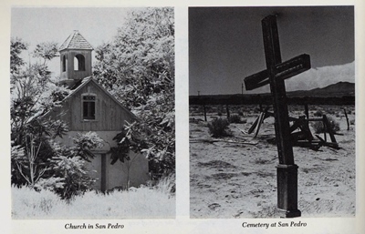
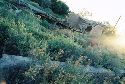
When Philip Varney visited San Pedro in the late-‘70s, he described a ghost town of more than a dozen buildings, including the wood and adobe San Pedro Catholic Church, complete with intact steeple, and another large adobe structure, once the home of a well-known landowner. Things have changed a bit over the last 30+ years and, while not exactly a booming metropolis, San Pedro is a little livelier than when Varney came through. Kinda like Chloride, but without the museum.
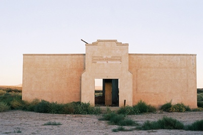
While there might be more actual residents these days (and perhaps meaner dogs, as well), there seems to be fewer buildings. The church is nowhere to be found, nor is the neighboring barbershop. The stately adobe residence has mostly sunk into the earth (and is guarded by one or two of the aforementioned pups). The schoolhouse, pictured at top, still remains though. Built by the W.P.A. in 1936, it closed shortly thereafter and is now owned by the family living next to it. They were kind enough to let me take a photo after finding me basically standing in their driveway when they came home one evening. Thanks, folks!
San Pedro was settled in the mid-1800s by two families, the Montoya’s and the Tefoya’s. By 1860, the town had a population of 223. At that time, the village,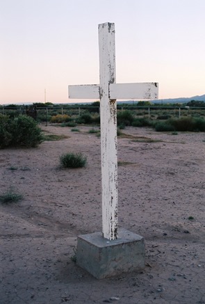 located on the east bank of the Rio Grande and close to El Camino Real, was a Spanish agricultural settlement known especially for its grapes. These grapes were crushed into wine reportedly shipped “all the way to Kansas.” The village was also a resting place and trading center for travelers on El Camino Real. Later, some residents became miners and worked in nearby Carthage and Tokay. Apparently, a heated baseball rivalry developed between the San Pedro and Tokay teams with a third forgotten community, Bosquecito, also in the mix.
The Rio Grande, that lifeblood of San Pedro--as it was for so many small towns--was the reason for San Pedro’s location and, finally, a major reason for its decline. All that remains of the section of the river that used to pass beside San Pedro is a dry, sandy bed, the result of canals that have shifted the course of the waterway almost a mile to the west.
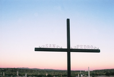
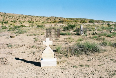
Varney described the San Pedro Cemetery as “windswept and desolate.” I love a nice, desolate, windswept cemetery, but in San Pedro the cemetery, too, has been modernized. A comparison of grave markers shows them to have been upgraded since Varney’s visit. While I have to admit that I prefer desolation, aesthetically-speaking, I’m happy for San Pedro. And I got in some desolate, windswept cemetery viewing in cold, cold Clayton last weekend.
We’ll get to Clayton and its famous decapitated dead man, Black Jack Ketchum, eventually, but we’re going to stay in sprawling Socorro County and head down to the banks of the Rio Salado to visit Riley (aka Santa Rita) next. Until then, be well, as both Garrison Keillor and Walgreens tell me these days.
Information for this post (and the b&w photos above) came from Philip Varney, of course. Additional help was courtesy of ghosttowns.com and, through them, Roadside New Mexico: A Guide to Historic Markers, Revised and Expanded Edition!
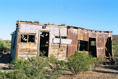
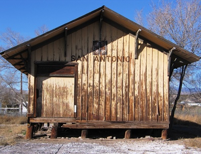
Last post we visited San Antonio, New Mexico, the spiritual home of the Hilton Hotels chain. San Antonio experienced a boom when coal mines ramped up production in Carthage, about 10 miles east. One of those early mines, the “Hilton,” was owned by August H. “Gus” Hilton. But, while San Antonio is still pretty hard to miss, especially if you’re looking for cranes at Bosque del Apache, three towns closely linked to San Antonio—Carthage, Tokay, and Frailey—have sunk deep into oblivion. In fact, even the true spelling of “Frailey” has been lost. You might see it referred to as “Fraley” or “Farlay” and either might be right. One spelling that is probably not correct is the one found on the NM Historic Marker beside nearby Highway 380, which has it as “Farley.” At top is what might have once been part of an auto garage, judging by nearby remains.
Carthage was the site of the first coal mine in New Mexico, the Government mine, which employed U.S. Army soldiers in the early 1860’s and supplied Forts Bayard, Selden, and Stanton. Construction of a railway to ship coal to San Antonio from Carthage began on March 1 of the year that seems to represent the zenith of the Wild West, 1881, when Billy the Kid died and there was a Gunfight at the O.K. Corral. I think the shot above might be the bottom of a tower used for watering locomotives.
The Santa Fe Railroad Co. finished a bridge across the Rio Grande in 1883 and, by 1889, Carthage topped the list of coal camps in the state with a population of about 300. But, by 1893, coal production was lagging, so the Santa Fe Railroad Co. made a deal to move the entire town to Cerrillos, NM. On August 17, 1893, the Old Abe Eagle reported, “…All the dwelling houses, coal chutes and machinery have already been moved. The place has practically been razed to the earth and the depot, adobe hotel and Gross, Blackwell and Co. are about all that remain.” The Santa Fe Railroad then promptly went into receivership on Christmas Eve. Almost two years later it would re-emerge as the famous Atchison, Topeka, and Santa Fe (AT&SF).
From 1894, coal extraction continued while mines changed hands and changed hands again. The abandoned Santa Fe Railroad Co. line finally ceased operating entirely in 1896 and then everyone spent some years trying to figure out how to get the railroad to run those 10 miles to San Antonio again. The difficulties of (re)building the short spur came to a head in 1905 when competing mining and railroad interests sued each other. Mining ceased for two years during the litigating. Finally, the case was settled out of court, 50 new miner’s homes were quickly built by the Carthage Coal Company, and production surged.
Then, on New Year’s Eve 1907, there was a massive explosion in the Bernal mine which killed nine miners, throwing two 300 yards from the site. Two more were seriously injured. It was said that many more would’ve been killed if it weren’t for the fact that the accident occurred during lunch and most men were eating. A somewhat lesser disaster struck Carthage on February 22, 1918, when coal dust ignited in the Government mine, killing one mine inspector who improperly used his safety equipment and a sparrow.
Mining continued for decades, but eventually with diminishing returns. The last train left Carthage on August 28, 1931. After that, things were really on the downswing, although serious mining interests struggled through into the 1940’s. The last mine, Tres Hermanos, was opened in 1980 by Cactus Industries. It was closed by 1981.
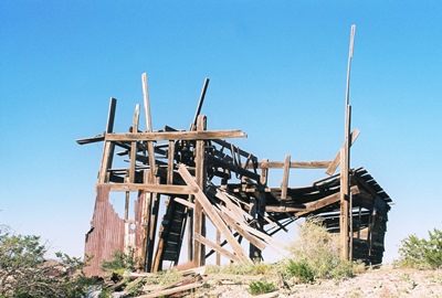
Now, if you look at the entry for Carthage on ghostowns.com, you will see a note dated April 2, 2000 which laments that most of what had remained of Carthage--apparently a fair amount--had recently been hauled off to a nearby dump.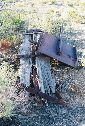 The “clean-up” was ostensibly part of a “desert restoration project” and, while I sure love the desert, I find this a little hard to believe. There is so much wide-open space in every direction out here that restoring this small area strikes me as bizarre. Not impossible though. On the other hand, “Ghost Towns and Mining Camps of New Mexico” stated in 1975: “Today what is left of Carthage is fast melting into oblivion.” Other than the impressive adobe ruins of the large home of a mine superintendent, John Hart, who left Carthage in the mid-1940’s, I have no idea what’s really been lost in the interim. At least the corpse of the small mining car above persists.
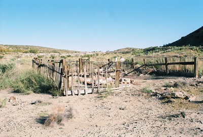
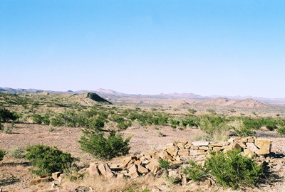
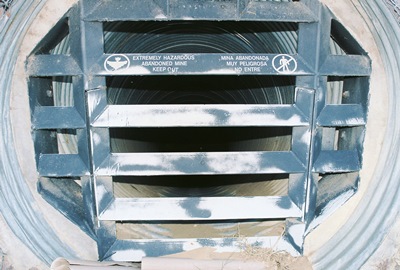
Whether Carthage disappeared recently or long ago, what remains now is hard to identify. Millions of pieces of broken glass glitter in the sun, a surprising percentage of them pink and purple. (So much for a restoration, eh?) A few stone foundations can be seen here and there. Several old mines can be located, all sealed and capped. Walking the raised rail trestle from the relatively intact Carthage Cemetery, it’s unclear where Carthage becomes Frailey, the site of a limestone quarry and kilns owned by Mr. J.B. Frailey, once the trainmaster at San Marcial, now also a ghostly town.
Then there’s Tokay, founded in 1918 by Bartley Hoyt Kinney, Sr., who was involved in the Carthage mines and organized the San Antonio New Mexico Coal Company. He wanted to name the town “Kinney,” but the post office refused. Finally, while talking to the postal inspector at Mr. Kinney’s general store, he saw a box of Tokay grapes and said, “How about Tokay?”
Tokay actually struggled into the late-1940’s, but eventually mining ceased and its structures were moved to Socorro. It would’ve been around here somewhere. But where? Who knows anymore? Just a few miles southeast is the Trinity Test Site, where, on July 16, 1945, the first atomic bomb was detonated. Carthage, Tokay, and Frailey, once sizable and active places, couldn’t be much more obliterated if they’d been at ground zero.
Hey, even Philip Varney didn’t have much to say about these three towns. There’s little to be found on Carthage, but, surprise, surprise, there is one scholarly article, “Mining History of the Carthage Coal Field, Socorro County, New Mexico.” It’s the best source, by far. I also consulted the aforementioned ghostowns.com. Even less can be found on Tokay and Frailey and what I managed to unearth was part of a good history of the railroad in the area formerly posted at New Mexico Wanderings. Old newspaper articles on the mine explosion can be found at gendisasters. And let's not forget Ghost Towns and Mining Camps of New Mexico by James E. and Barbara H. Sherman.
Next time, we’ll make a quick stop at San Pedro, just between Carthage and San Antonio.
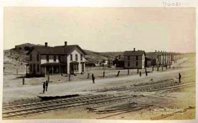
Around the turn of the 20th Century, a boy would walk from his father’s mercantile store, which also served as a hotel, to the train depot (shown above), just a short distance away. This boy then carried the luggage of passengers newly arrived in San Antonio, New Mexico back to their rooms, which ran $2.50 a day and included meals. The boy met every train stopping in town, regardless of time or weather. In 1919, that boy, Conrad Hilton, now thirty-two years old, bought the Mobley Hotel in Cisco, Texas and thus began the Hilton Hotels chain. Paris Hilton is his great-granddaughter.
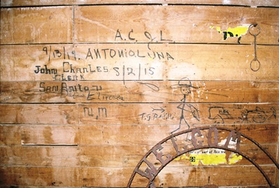
Below is a shot of some almost 100-year-old graffiti from inside the depot. Note the infinity sign/hat brim. Could it be the mark of the original train-hopping Bozo Texino?
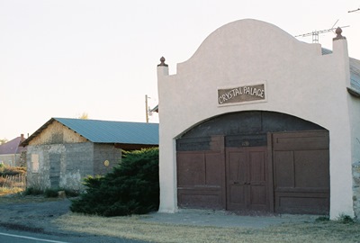
San Antonio can trace its history back to 1629 and the founding of the San Antonio de Senecú Mission. The Apaches succeeded in destroying the mission in 1675 and for over 100 years the burnt remains of the village, which had been inhabited by Piro Indians for a mere 700 years prior, slowly decayed out on the plains, a caution to travelers on the nearby Camino Real. Now those ruins have been fully reclaimed by nature and the exact location of San Antonio de Senecú is unknown. On the other hand, the Crystal Palace, below, was once a dance hall and then a much more dilapidated (and photogenic) auto garage, but someone eventually decided to kinda fix it up.
Hispanic farmers from northern New Mexico established present-day San Antonio in 1820 and, when the Santa Fe Railroad arrived in 1880, the town shifted to be closer to the rails. While most of San Antonio’s 1,250 residents still raised livestock, made wine, or even kept bees, the railroad was soon extended 10 miles east to reach the coal mines of Carthage and Tokay. Stakes included a claim known as the Hilton Mine, owned by A.H. “Gus” Hilton, who used the money to found the A.H. Hilton Mercantile Store. Mr. Hilton’s son, Conrad, was born on Christmas Day, 1887.
For almost 50 years the mines paid out, the trains came and went, and stagecoaches ran between White Oaks, Fort Stanton, and Lincoln. However, by 1925, the mines were going bust and the railroad soon took up its tracks.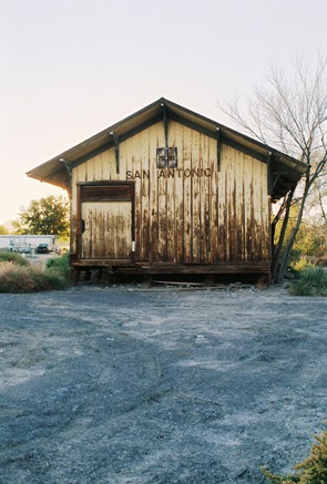 Then two major floods in 1929 washed away a big chunk of the town and the surrounding farmland. WWII lured away most remaining young men and A.H. Hilton’s original mercantile burnt around the same time, which, incidentally, pretty much coincided with Conrad's marriage to Zsa Zsa Gabor. However, Hilton’s wooden bar was saved and installed in the famous Owl Bar and Restaurant in 1945, where it is used to this day to support Tecate and green chile cheeseburgers. The Owl Bar itself was built by Brunswick Balke Collender Company. You might have used their bowling balls.
And that is largely where San Antonio is at today, except for the slight shift to the north, where most business is now conducted along U.S. 380. Not a true ghost town, you still won’t find any trains stopping at the marooned and badly listing depot. Of course, every ghost town aficionado hopes to discover something new, and,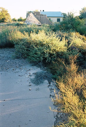 while it’s well-known that all that’s left of what could be considered the original Hilton Hotel is its foundation, located across from the old post office (now a restored private residence), I have been unable to find a single picture of the site anywhere. So, as is my wont, I took my own. In fact, I took two. The concrete shown here and below is all that remains of the birthplace of one of the greatest hotel chains in the world, without which Paris Hilton might be living in a trailer out in the Socorro County desert. However, the original ballroom floor from the hotel was reportedly installed in the Wool Warehouse building in Magdalena. It must've been part of a remodeling job as that place was built in 1913. Can anyone get me in to have a look?!
For those Paris Hilton fans wishing to tour the old ruins, I can be hired at a very reasonable price. Please wear sensible shoes and long pants and don’t expect much.
Info for this post came from Varney and Harris. Special thanks to the grandson of the owners of the San Antonio depot for the quick peak inside. Next time we’ll visit the aforementioned Carthage and Tokay. Or, at least, an area the might as well be.
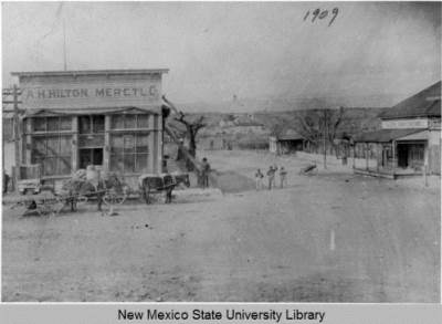
APRIL 2014 UPDATE: Thanks to Jerrysocorro P, a wonderful photo of the A.H. Hilton Merctl Co building has been brought to my attention. Apparently taken in 1909, this is a rare image indeed. It shows the corner on which the above ruins were photographed. Across the street is a building signed as "City Drug Store." This is what was later the post office and still stands as a private residence.
Very interesting to me is the building behind the mercantile. Unfortunately, you can't see it on the downloaded photo, but behind the skeletal tree is a sign on which you can read " OT L". The best way to have a look for yourself is to go to this page. Is this another "Hilton Hotel"? I can't imagine San Antonio supporting two hotels when it couldn't support a bank.
This excellent biography (thanks again, Jerrysocorro P!) on Conrad Hilton mentions a "makeshift hotel" where for $1 you got a room and a hot meal. It also specifically states that there were rooms in the mercantile, although the merc looks rather un-hotel-like. So what is this second apparent hotel? 'Tis a mystery.
Kudos to the University of New Mexico and NMSU for making historical photos like this one available on-line.
Because I only manage a "real" post here once or twice a month, I've created a City of Dust page on Facebook. I will try to add a new ghost town or abandonment photo every day and, while most of the shots will be from New Mexico, I'm sure I'll get distracted every now and then. I hope this Facebook page might spur more discussion and interaction, as well. There's lots of stuff I'd like to know about the places I shoot and now it'll be easier for folks to tell me. However, never fear, this blog will always remain my bread and butter. If you want to have a look at the Facebook page, go HERE.
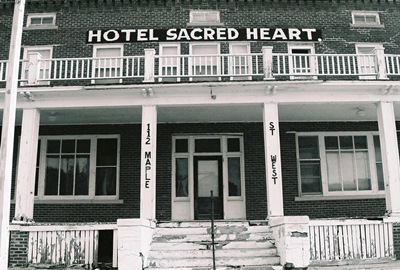
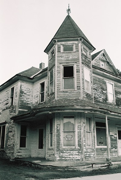
Speaking of getting distracted, below is a haunted house just in time for Halloween. This was taken in September in Sacred Heart, Minnesota, way out on the prairie. The photo above was also taken in Sacred Heart, believe it or not.
The next post here should be on San Antonio, New Mexico, from where the line runs directly down the old railroad tracks to...Paris Hilton. Until then, thanks for your interest and Happy Halloween!

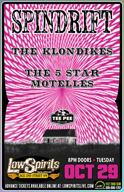
We interrupt our regularly scheduled program to mention that Spindrift’s fantastic new album, Ghost of the West, was released today. The band is a totally compelling blend of Tex Ritter, Ennio Morricone, Pink Floyd, and Hawkind. When was the last time you heard something like that? To listen to a sample track, visit this recent piece at the Onion’s A.V. Club.
While you’d want to buy the record just for the music, I personally think the cover art is kinda cool, too. Yup, that’s the First Presbyterian Church of Taiban. While I might consider letting almost any band use one of my photos (well, except Foreigner or the Eagles), it sure makes things nicer when the band in question is one of such quality and style. Not to mention, their interest in the West is real. This will become even clearer when a DVD of their 2012 Ghost Town Tour is released next year. Did I mention the album is on vinyl, too? Check Tee Pee Records, Amazon, etc.
Also, for those of us in Albuquerque, Spindrift is playing Low Spirits next Tuesday, October 29. See ya there.
With a population of 1,956 as of the 2012 census, Gamerco, New Mexico might be the biggest town we’ve ever featured on City of Dust. It ain’t a ghost town, that’s for sure. But it’s also lost its original reason for existing: coal. Gamerco is actually an acronym for the Gallup American Coal Company, which operated area coal mines for two years before lending its name in 1922 to the town developing around its operations.
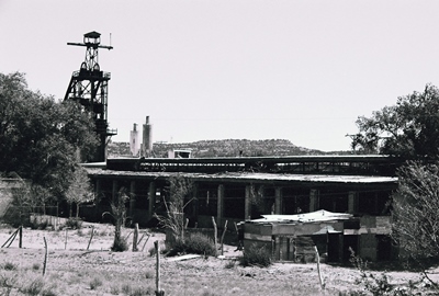
At one point, five hundred miners and their families lived and worked in Gamerco and reportedly loved it. The company took care of them by paying well, ensuring a safe workplace, and keeping hours reasonable. Along with the processing and power plants and the rail spur needed for its day-to-day business, GAMERCO built homes and apartments for its employees, as well as a church. Workers even passed on unionizing figuring things couldn’t get much better. Well, those days seem to be long gone most everywhere and for Gamerco they left in the 1960’s. That was when the company closed its mines, shuttered the power plant, and moved the rail spur.
People still live in some of the old residences and in the former Gamerco offices. I badly wanted to explore the old plant, but a group of people seemed to be living in a trailer out back there, too. Someone might have also been living inside the plant. In any case, I figured I wouldn’t go down and say “hello.”
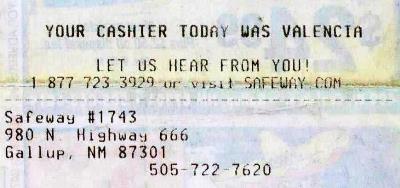
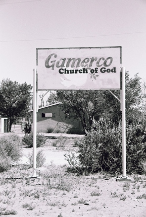 Gamerco used to be just off U.S. Route 666, the “Devil’s Highway,” but that treacherous stretch of road was renamed U.S. Route 491 in 2003. Although, I believe it’s still just as treacherous. Happily, the Safeway in Gallup still hasn't got the memo. Without any coal, Gamerco’s most well-known export is perhaps Onawa Lacy, Miss New Mexico 2006 and a competitor in the Miss USA pageant. The town might soon be annexed by Gallup. Whether that means Gamerco will then lose its name, too, who can say?
Gamerco was good enough for Philip Varney, so it’s good enough for us! Other information came from Gamerco’s Wikipedia page. Ghosttowns.com also has an entry and some photos. Beyond that, there just isn't much out there on the old town.
Until next time.
It’s seems like it’s been a very long time since I’ve done a proper post, but I guess it’s only been a month. In that time I’ve been conducting experiments in exhaustion. I like to do this from time to time even though the results are always the same: Days begin to feel like lifetimes, I become very forgetful, and then I get sick. So, here I sit with a cup of a homeopathic Thera-Flu-like drink that will probably have me nodding off at the keyboard while I try to remember where I was in late-July, which might as well have been the 1980’s for how recent it feels now.
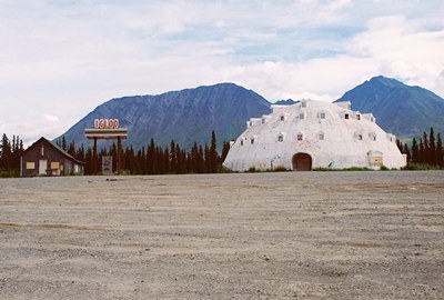
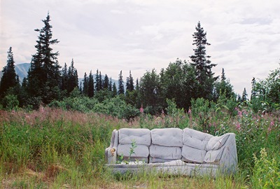
Anyway, occasionally City of Dust likes to head further out on the road than usual. Over the past few years we’ve been to Hungary, Germany, and Cambodia. While Alaska might not sound quite as exotic to a North American, it sure feels pretty exotic when you’re there. Sort of like living in Jurassic Park but instead of dinosaurs you get eaten by grizzly bears or trampled by moose and go crazy because the sun never sets. While lots of buildings look derelict, I didn’t find much that was truly abandoned to explore. Probably because the cruel winter destroys anything that’s not regularly tended, unlike out here in the desert. For a while I thought the only thing I might have to report on was the over-the-top level of public intoxication I witnessed in Fairbanks. But then I found an abandoned igloo.
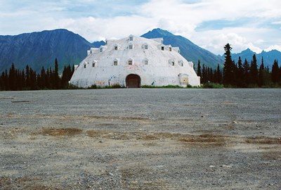
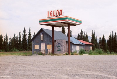
Large enough to be seen from planes at 30,000 feet, the Igloo City Hotel, conceived as a tribute to the Inuit people and built by a man named Leon Smith, was clearly a beautiful idea.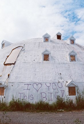 Four stories tall and made of concrete--not ice--with a lovely mountain backdrop, the only flaw in the plan might’ve been building the place 180 miles from Anchorage and almost the same distance from Fairbanks. In fact, it’s way out there on the George Parks Highway, 20 miles from Cantwell (pop. 222), the nearest town. While there is a relatively constant (for Alaska) stream of traffic traveling between Anchorage and Fairbanks, staying at this hotel would’ve put you in proximity to the now-also-abandoned gas station across the parking lot and not much else in the way of civilization.
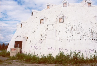
The structure was never close to being completed and the interior is just bare ribs made of hundreds of 2” x 4”’s, which I couldn’t see during my visit because there was nothing but darkness when I poked my head through a loose board. Mr. Smith apparently violated building codes by making the windows too small, started to run out of money, and then was hit by rising fuel costs even before the business itself had a chance of failing. But beyond the tiny windows the structure must’ve been otherwise well-built; the Igloo City Hotel was begun in the 1970’s and has now survived, vacant and exposed, for possibly over 40 Alaskan winters.
Of course, one man’s dream is…another man’s dream, also, and the Igloo City Hotel was sold a few times only to end up back in Smith’s hands after buyers missed their payments. Before dying, Smith, in failing health and concerned for his wife’s future, finally sold the property to Brad Fisher of Fisher’s Fuel Inc., who didn't actually want it. After Smith accepted his lowball offer, Fisher remembers thinking, "Oh no, that's not really what I wanted to happen!"
Fisher did end up operating the gas station and some adjacent cabins while trying to renovate the hotel, but finally ran out of money himself in the early 2000’s. The gas station and cabins were shuttered in 2005. Mr. Fisher now also has Igloo City, the old gas station, and the surrounding 38 acres up for bid, but will only sell to someone serious about completing the decades-old project.
Hopefully, an enterprising individual will buy the place and give it another chance. Word is that most locals consider it something of a landmark and someday I’d sure like to spend a night in Igloo City. I'd probably need the rest.
The full story of Leon Smith and his vision of an igloo-shaped hotel in the Alaskan wilderness may forever go untold. But most of the basics have been repeated on several websites that have featured Igloo City, although there are some errors that have proliferated. The best source on the history of the hotel is a STORY from earlier this year in the Alaska Dispatch, which features the quote from Mr. Fisher used above. If you’d like to see the wooden inside of the igloo, Kuriositas has a nice collection of shots.
I wanted to break into our regularly scheduled programming for a moment to mention that I was recently invited to contribute to Duke City Fix, a website exploring all things Albuquerque. My first piece several weeks ago was a re-working (read: shortening) of an epic post I did in early 2010 on the Atchison, Topeka & Santa Fe Rail Yards, by far my favorite place to photograph in the city. I followed that up with a companion piece on the WHEELS Museum, a great repository of rail and transportation history and the only actual tenant at the rail yards. My third article, a recounting of a Sunday morning stroll down a battered yet still enthralling Route 66, was published ten days ago. I'm kicking ideas around for the next bit. Let me know if you have any suggestions.

The content of these can be a little different than what I do here, but you’ll still recognize the, uh, aesthetic, I think. If you’re interested in reading more, just follow the links in the text above (2020 UPDATE: Links are long dead). The WHEELS piece features the finest picture of an antique milk truck that I've ever taken. I’d like to thank Duke City Fix for the opportunity. I’m honored to be involved.
The next post will be a one-off stop in Alaska to take a look at a bit of entrepreneurial failure. Seriously.
Someday I’ll tell you a tale of a town that didn’t owe its very existence to the railroad, whose citizen’s livelihoods weren’t later subject to the capricious placement of state and federal highways, and which didn’t finally find itself cut-off from the travelers that were its lifeblood. But it ain’t gonna be the story of Duran.
In February 1902, the El Paso & Northeastern Railroad finished the “Arrow Route,” a stretch of track between El Paso and Santa Rosa, where a connection to Leadbelly’s Rock Island Line awaited. Blas and Espiridón Durán, two brothers, owned wells in central New Mexico which could provide water to railroad work crews. So, the railroad built repair shops and even a wooden roundhouse in what became Duran. The railroad also turned the town into an important supply point for area ranches virtually overnight. Duran’s population probably peaked shortly afterward at 300 or so.
But the railroad eventually moved its operations south to Carrizozo and the roundhouse came down in 1921. Yet Duran remained important to ranchers and, when two-lane U.S. Highway 54 came right through the heart of town in the 1930’s, the increased flow of north-south traffic gave Duran another boost. This lasted until the 1960’s, when I-25 was constructed about 60 miles west, strangling U.S. 54 of travelers.
Duran is not a true ghost town. It still has residents--probably around 35, in fact--but two of its most interesting buildings are long-abandoned. One, shown below, is a two-story building made of buff-colored sandstone marbled with white. This was a general store and hotel. Badly faded lettering above the doors reads: “dry goods furniture hardware grocery & feed’s”. It’s still a beautiful building whose quaint façade belies a sinister and surprising history.
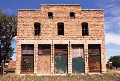
The building was owned by Anton J. Coury, a man of Lebanese descent, who lived with his wife, Raffa, and children, Fred, Anna, and Emma, in the upstairs hotel. On September 3, 1921, the store was robbed by five men and Mr. Coury was shot and killed while resisting. Raffa was also shot and severely wounded, reportedly surviving only because a potentially lethal bullet struck the metal clasps of her corset and was deflected. Young Freddy then bravely intervened, driving away the thieves by relentlessly pelting them with canned goods when their gun jammed. I don’t know if the store ever opened for business again.
A search for the killers began immediately and Francisco Vaisa, Isodoro Miranda, and Carlos Rentenería were quickly caught. Luis Medrano was apprehended some months later. The fifth man, Eziquel Machucha, was never found and it’s believed he escaped back into Mexico.
The prisoners were sentenced to be hung on July 28. 1922, but Vaisa appealed his conviction and bought himself some time. On the appointed day, in Estancia, about 40 miles northwest,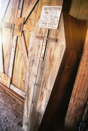 with Mrs. Coury and her children observing, the other three men were brought to the scaffold as the sun rose in the east. Asked for final statements, Rentenería said a few unrecorded words and Medrano said nothing. But Miranda said, “In New Mexico, there is no justice for the poor man. He is led like a helpless lamb through the courts and to his punishment. This is an injustice you are now doing.” Then Sheriff John Block led the men behind a canvas drape, the low sun casting stark silhouettes against the fabric. The day broke in earnest as the men dropped to their deaths.
It didn’t take long for Vaisa’s conviction to be upheld and, on April 6, 1923, he, too, was brought to the gallows in Estancia. With few observers and after offering that he had no final statement to make, John Block adjusted Vaisa’s noose, the trap door opened, and Vaisa fell as the sun again crested the horizon. He was the 75th and last person to be legally hanged in New Mexico.
Here at City of Dust we like to get our facts straight, which is difficult with the internet around. The more commonly cited story of the above attack includes four robbers striking in the dead of night, with three men being hung and the fourth getting the electric chair. Also, the robbery occurred in 1914. Is the devil in the details? Well, the story I recounted is clearly better and, while I wasn’t there, that version is from “Myth of the Hanging Tree: Stories of Crime and Punishment in Territorial New Mexico,” by former New Mexico State Historian Robert J. Torrez. Mr. Torrez cited contemporaneous editions of the Estancia News-Herald and seems pretty reliable to me.
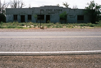
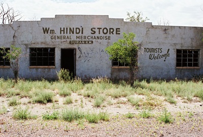
In any case, William Hindi was also from Lebanon and operated a store in Duran, the eye-catching building above and at top, which opened in 1908. It is also constructed of cut stone and its signage still clearly welcomes tourists, but much in the world has moved on while the little store has stood still. At least the graffiti inside, some of which reads, “go hug someone,” “god rox,” and “satan is gay,” would lead one to envision a history far more whimsical than that of the general store. William's brother, Kasim, also operated a store, but his was across the highway from the Coury Merc. Co.
Other buildings around Duran are still in use, including the San Juan Bautista Catholic Church, built in 1910, the red brick school, which closed in 1955 but has been re-purposed as a community center, and the fire station and post office. Thus, unlike some other towns where the trains now whistle right by and motorists are few and far between, Duran persists. It also most certainly sees fewer hanging crimes.
The jumbled tale of the robbery of the Coury family may have originated with a resident of Duran and is retold at ghosttowns.com. To read the more academic version, see Torrez. There is also an odd tale of a boy from the East Coast hitchhiking back to Duran in the 1960’s and starting a life. And that’s everything I could find about Duran. Oh, and the shot of the coffin is from Apacheland Movie Ranch in AZ, not Duran.
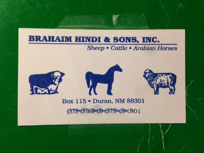
APRIL 2014 UPDATE: I received a very interesting message regarding the Hindi's from Tere O., who has kindly agreed to allow me to post it here. Some of you with roots in Duran might find this of particular interest. Thanks, Tere!:
"Wow, I wish you could have visited with Brahaim Hindi (card above). He lived in Duran and would have been a lot of help with information. Somehow I want to say he has a brother named William but I’m not sure. I’m trying to recover information about Duran for my family that is growing up and they are interested in our history.
"We went to see Brahaim Hindi about a year ago. My mom knows him very well. My Aunt Sara worked for the Hindi’s for years in Duran. She helped raise the children, too. My mom, Agneda, is living with me now but she has dementia and cannot remember much. However, she knew that Brahaim lost his wife and son on the same week and wanted to pay her respects to him so I took her to his house to see him.
"Now he has become quite ill and is living here in Albuquerque with his daughter, or so I hear. I live on the same street as Apolonio S. and his wife, Sandra. He was the postmaster in Duran. I am the granddaughter of Simplicia and Lazaro Montoya. I just posted the coat of arms of the Montoyas on my Facebook page yesterday.
"Hope this info helps you on the journey you have to keep all of us informed."
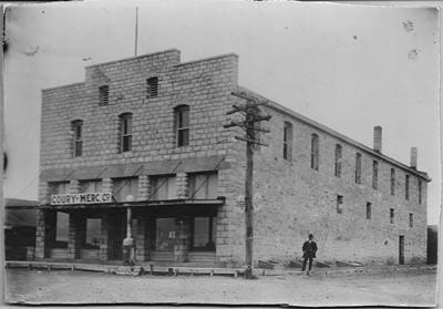
APRIL 2014 UPDATE: After the update a few days ago from Tere O. we get another, this time from S. Hindi, who clears up the picture of Duran, the Hindi family, and who owned (or owns) what store entirely. We also get a great photo of the Coury Merc Co. Incredibly, that is Anton Coury standing at the side. Here is the story:
"The picture (above) is of the Coury Mercantile/boarding house with Anton Coury out front. My husband, Joseph Hindi, bought this building from Raffa Coury, widow of Anton who was shot inside. I have a lot of info on the shooting.
"Also, the William Hindi building across the street was owned by my husband's uncle, Brahaim. William is Brahaim’s uncle. William and Alex Hindi came from Lebanon. The town, Duran, is named after my husband’s grandmother's family. Alex married Clarita Duran and had Brahaim, Sam, Nabay, Shafie, Ednen, Samia, and Hafiza. Shafie is my husband's father.
"Alex became a rancher/Arabian horse breeder and William had the store. Kasim also had a store and is related. There are lots of Hindi’s from Duran. All related. You need to talk to my husband because I may have some of the connections wrong. I’m trying to write a screenplay on the shooting in Duran."
That's an impressive summary. Many thanks for straightening all that out, S. Hindi! Your contribution is very much appreciated. And I really look forward to hearing more about that screenplay. JM
MAY 2014 UPDATE: W.B. Hindi recently sent me a message adding even further detail to this story, particularly William Hindi's background before he opened his store in Duran. Mr. Hindi kindly agreed to have his recollections posted here for all to read:
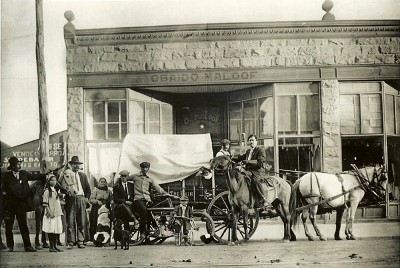
"I came across your blog on the internet concerning my grandfather’s store in Duran, N.M. My name is W.B. Hindi. My grandfather’s name was Milhelm Hindi, which he changed to William sometime after he arrived here from Lebanon at the turn of the 20th century. When he first got here he actually sold goods out of a buckboard. He sold them in Northern N.M. and into Southern Colo. He bought them from the grandfather of the Maloofs who at one time owned Coors distributing in Albuquerque N.M. I have a picture of him on horseback in front of the Maloof store in Las Vegas N.M.
"His brother, who people are calling Alex, was actually named Ali. William brought Alex over to become his partner in the sheep and cattle business. Since they settled in Duran, which bordered Lincoln County, shortly after the cattle wars of Billy the Kid fame, this may have been the reason he elected to raise both sheep & cattle. He also started breeding Arabians for ranch work and would often take a few along into northern N.M. to sell. There are books that I believe Brahaim has that trace many Arabians in this country back to their heritage from The Hindi Ranch.
"I am still picking my uncle's brains to get more of our history while I can. I am going to forward your blog to my Uncle Azeez and he may possibly be able to fill in some more gaps."
Those are some great pieces to have added to the picture and we're beginning to learn a lot about the origins of the store at the top of this post. Many thanks to W.B Hindi for being so helpful and generous.
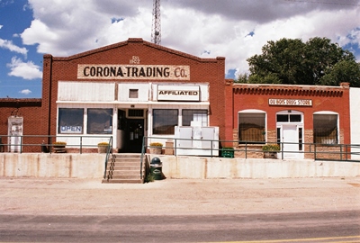
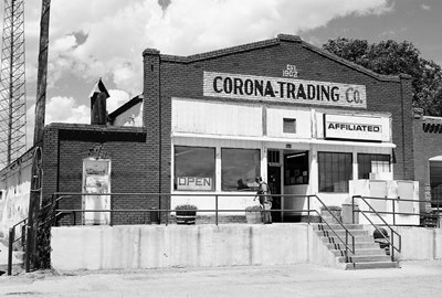
By the way, the Corona-Trading Co. and Du Bois Drug Store, shown at the top of this update, aren't in Duran, but Corona, which you'll find a few miles to the southwest on Highway 54. Established in 1902, six years before the Wm Hindi Store, I imagine the Hindi family would've known the Corona-Trading Co. well (and perhaps still do!).
JULY 2014 UPDATE: I'm sorry to report that the Corona-Trading Co., pictured just above and now shown just below, in operation since 1902, has recently closed. Hopefully, I'll be able to do a full post on Corona, NM someday, but, for now, here's to hoping someone buys the old trading company and starts watering those flowers again soon.
JUNE 2015 UPDATE: I received a great historic photo from W.B. Hindi which, while not specifically of Duran, is certainly Duran-related. I'll let Mr. Hindi explain further (see MAY 2014 UPDATE for more from Mr. Hindi, including a reference to the shot below):
"This is a picture of my grandfather, William (Milhelm) Hindi, loading supplies in 1910 in Las Vegas, NM. He is the gentleman on horseback. I think this is a great photo as it mixes the old (wagon and horses) with the new (motorcycle). I just wish I knew more about it. What is really neat is that Maloof's store was owned by the grandfather of the Maloof's from Albuquerque, whose dad built a small liquor store up into the largest Coors distributorship in the Southwest."
Thanks for the rare and wonderful photograph, Mr. Hindi!
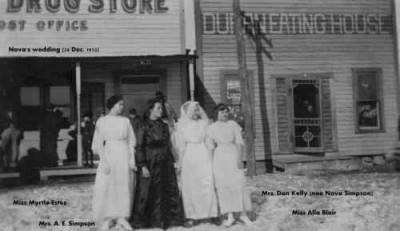
JULY 2015 UPDATE: Below is another wonderful vintage photograph, this one from N.E. Welch. According to the labels on the picture, it depicts the wedding of Mrs. Dan Kelly (far right; née Nova Simpson), occurring in December 1910. Other women in the photo are Mrs. A.E. Simpson (center, in black), Miss Alia Blair (second from right), and Miss Myrtle Estus (far left). The drug store/post office and Duran Eating House, which the Simpson family operated, were on the north side of the railroad tracks, just west of the Coury Merc Co. One of the Simpson children, William, or "Bill," was sheriff of Luna County when Pancho Villa made his raid on Columbus, NM. Note the snow on the ground. The original photo was donated to the Museum of New Mexico in Santa Fe by Mr. Welch's older brother.
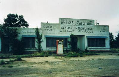
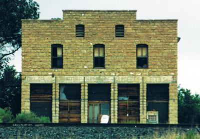
NOVEMBER 2015 UPDATE: Ian Wheeler of Australia has graciously submitted a couple photos from his trip through Duran in the mid-1990's. The first shot is of the mysterious Kasim's Cash Store in all its still-signed glory, complete with vintage gas pump. William, who owned the general merchandise store at the top of this post, was the brother of Kasim's mother and thus Kasim's uncle. Kasim's Cash Store still stands, but has been painted over and is therefore harder to identify, not to mention less interesting. Now we've got photographic evidence of both stores as they were and the full story of just who owned which. The second photo is obviously of the Coury Mercantile Company, but with its doors and windows in rather more authentic condition.
Many thanks to Mr. Wheeler for digging these out and passing them along!
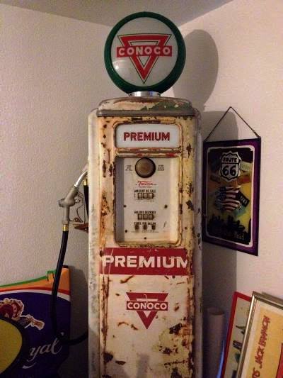
JANUARY 2016 UPDATE: What we have below is a Tokheim 39 gas pump that was made in November 1946 and was once somewhere in Duran. It was purchased in Alamogordo, NM in 2015 and is now in Germany, believe it or not. As you can see, it still has the original Conoco design. If anyone remembers where this pump used to be located (or perhaps even has a photo of it!), please leave a comment below. Both its current owner and myself would love to know! It's a nice one, eh?
Thanks to Bernd for submitting this little bit of Duran highway history.